
Delaney Crescent, Toronto
- Peter J. Marshall

- Nov 12, 2023
- 11 min read
Revised June 24, 2025.

The Delaney Block History
Every property in Toronto located between Queen and Bloor Streets can trace its ownership back to John Simcoe’s 1793 scheme to lure Upper Canada’s nascent gentry to the newly founded town of York. Having decided that the remote outpost would become the province’s temporary capital, the Lieutenant Governor enticed senior members of the military, government and judiciary to relocate there from the then capital of Newark (Niagara-on-the Lake) and the more prominent settlement of Kingston by offering large tracts of land near town for only £1 per acre. This included 100-acre “Park Lots” laid out in narrow north-south strips running between present day Queen and Bloor Streets and the story of the Delaney Crescent block begins with Park Lots 30 and 31.
Park Lot 30 spanned from west of today’s Sheridan Avenue to west of Mechanic Avenue and was first granted to James Brock in early 1812. James was a cousin and private secretary of Isaac Brock who arranged for him to receive 1,200 acres of land to compensate for his relatively meagre government salary[1]. James returned to England in 1815 and when he died in 1830 his wife Lucy inherited his estate. Lucy began selling off his lands but held on to Park Lot 30 until 1850 when she had it subdivided into smaller building lots and bisected the tract with a new road that would become Brock Avenue. Both the street and the village of Brockton that had sprung up around its intersection with Dundas Street were named in honour of Isaac.

Excerpt of 1851 J. O. Browne Map of the Township of York showing Toronto's original Park Lots. Lucy Brock's subdivision of Park Lot 30 is unique among the western lots which are all undeveloped. At this point the city of Toronto extended only to Dufferin Avenue which was the dividing line between Park Lots 28 and 29. (University of Toronto Map & Data Library)
Lucy sold the first of the building lots in 1850 and the following year she sold additional property to the Ontario Simcoe & Huron Railway to build Toronto’s first railway line which began service in 1853. 1853 was also when she sold a parallel piece of land to the Toronto & Guelph Railway who opened their own line in 1856 under their amalgamated name of Grand Trunk Railway.
After Lucy died in 1859 her estate continued to sell off properties within the former Park Lot. This included the creation of subdivision plan 319 in 1871 which contained the lands that would become the site of the eastern portion of Delaney Crescent as well as Mechanic Avenue.

Lucy Brock's estate updated her subdivision plan in 1860 to include the two railway lines which had been constructed in the intervening years. Click on the image to see the full plan that spans from Bloor Street to Queen Street which was then known as "Lakeshore Road" west of Dufferin. (Ontario Land Registry)
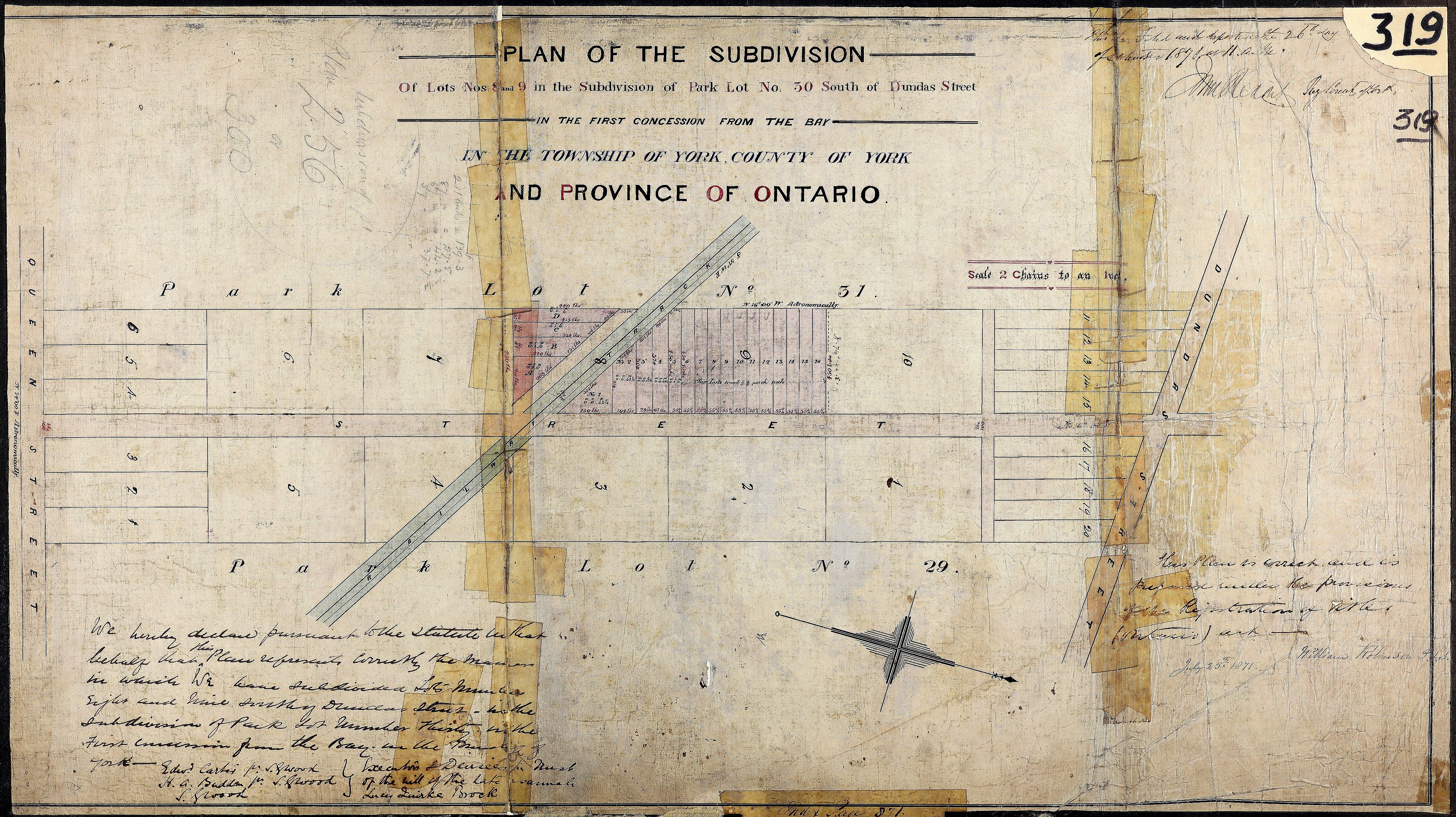
In 1871 Lucy's estate subdivided Lots 8 and 9 of the original plan and registered it as plan 319. It consisted primarily of 37-foot wide east-west tracts running west from Brock Avenue[2]. (Ontario Land Registry)
To the west of Park Lot 30, Park Lot 31 developed at a slower pace than its neighbour. The first subdivision of lands south of Dundas Street didn't occur until 1874 with the registration of plan 363 covering the land between St. Clarens Avenue and Park Lot 30. Included in the scheme was the first leg of Delaney Crescent: a north-south roadway called Maude Street[3].
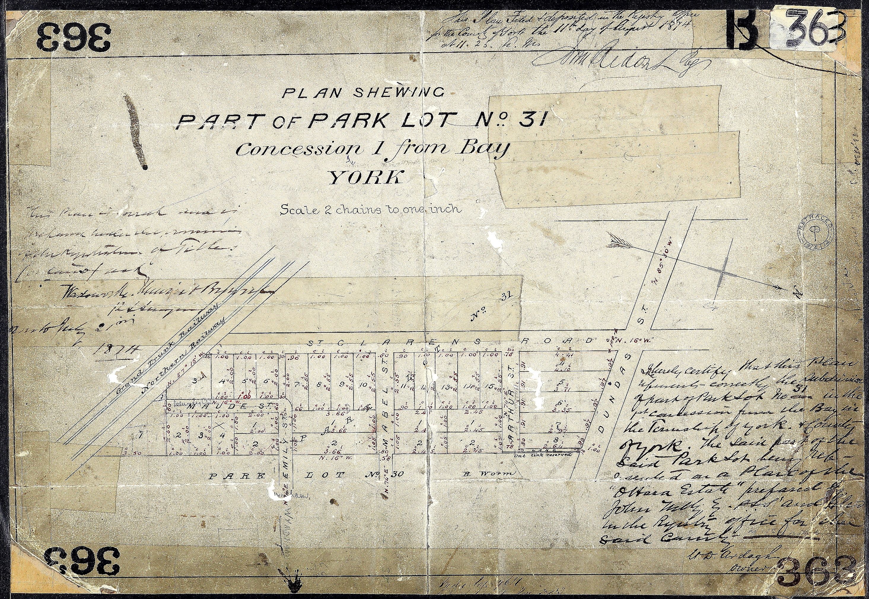
Subdivision plan 363 included the original stretch of Maude Street, running south from Emily (now Wyndham). It also extended Emily and Shirley (renamed Mabel here) west from their original segments in Park Lot 30 that were laid out in 1870. (Ontario Land Registry)

The 1884 Goad's Atlas of the City of Toronto and Suburbs is overlaid here with Park Lot numbers and borders. Numbers in ovals are subdivision plan numbers. At this point the block is still largely undeveloped with only a smattering of wood frame houses (denoted by yellow shading) located along Brock Avenue. (University of Toronto Map & Data Library)
In 1885 the city passed a by-law to "open up, widen, establish and extend Maude Street, from Emily Street [now Wyndham] to Brockton Road [Brock Avenue]" for the convenience of the property owners on the original stretch of the road. On New Year's Eve 1888 the street name was changed to avoid confusion with another Maud Street that existed in the city prior to Brockton’s annexation by Toronto[4]. The following month construction was completed on sewers for Delaney's houses and by March 1890 the street had been paved with cedar blocks at the request of property owners. The cost of both improvements was charged to those owners under the city's "Frontage Tax" policy of the time: the $1,765.46 sewer investment would be spread over twenty years while the $1,217.03 cost of the paving would be recouped over ten years.

In the 1890 Goad's Atlas of Toronto Maude Street has been renamed as Delaney and extended to Brock and Mechanic Avenue appeared as the last of the neighbourhood roadways. (Toronto Archives)
By the time the 1890 edition of Goad's Atlas of Toronto was published the immediate neighbourhood had been flooded with new homes. The houses are all very modestly sized, grouped in semis, triplexes or rows and almost all of them were of wood frame construction. The narrow houses, inexpensive construction materials, small lots and postage-stamp front yards were typical of the working class neighbourhood erected steps from four railway lines that would have been a source of constant noise and pollution emitted by passing steam trains.

The 1924 Goad's Atlas of Toronto Volume 2 reveals that the neighbourhood's development is largely complete now that many of the previously vacant lots have been populated with houses, most of which are notably constructed of brick as indicated by pink shading. (Toronto Archives)
1941 Underwriters Survey Bureau Insurance Plan for the City of Toronto Volume 4. Insurance Plans provided more specific construction detail than Atlases , including denoting brick veneers on wood frame houses. (Toronto Reference Library)
While the neighbourhood's physical characteristics were largely established by the 1920s its demographics and identity have continued to evolve. For much of the twentieth century the area lacked a distinct identity and was viewed by many Torontonians as an extension of Parkdale. In the 1980s a group of students at Bloor Collegiate Institute set out to change this misconception and successfully lobbied the city to erect Village of Brockton street signs throughout the neighbourhood, harkening back to its Victorian-era origins. At the same time, the Portuguese Canadian community was spreading westward from its original hub at Bathurst and Dundas so when the city established its official neighbourhoods in 2001 the south half of Brockton Village became a part of Little Portugal. The area's resulting dual identity is evident in a mix of street signs and business names along the Dundas Street thoroughfare and perhaps epitomized by the highly popular Portuguese pastry shop which opened as Brazil Bakery then later renamed themselves Brockton Village Bakery.

The generally accepted unofficial boundaries of Brockton Village[5] are marked in red and overlaid by the city's official boundaries for the Little Portugal and Dufferin Grove neighbourhoods in blue. (Peter Marshall)

More recently, the skyrocketing cost of Toronto real estate has resulted in early signs of gentrification as young professional couples are drawn to the relatively affordable cost of housing in a neighbourhood that offers a safe place to raise families along with all the perks of city living. Designer renos can now be seen mixed in with dilapidated dwellings and the local stretch of Dundas has developed a hip factor that rivals Queen West.
The J. J. Graham Semis: 6-16 Delaney Crescent

Of course, the true nature of a neighbourhood's origin is best derived not from records of massive land grants to well-connected government officials but from the individual stories of the first people to construct, purchase and occupy the individual homes on that land. The histories of numbers 6 through 16 Delaney Crescent provide exactly this kind of insight.
Their tale begins an overcast but balmy day in May of 1887 with builder J. J. Graham purchasing 90 feet on the north side of the newly extended Maude Street. The 34-year-old Graham had moved to Toronto from Aurora four years prior and within a couple of years would become a real estate agent and also serve as a city alderman from 1892 to 1908. But on that spring day his immediate goal was to construct and sell three pairs of semi-detached homes as quickly as possible.

John James Graham circa 1891 (Toronto Old and New)
The six houses erected by Graham featured facades that were a blending of Gothic Cottage and Half-Bay-and-Gable architectural styles. Overall, they were identical except for the the easternmost pair having their basements built below ground level while the two other pairs had theirs partly above grade. All houses had six rooms within their 14 ½-foot widths and were constructed of wood frames with brick veneer on the facades. The properties all had fences to divide the back yards and sheds in the rear that were accessed by a laneway. The house lots were a modest 90 feet deep and had irregular widths with the two outermost lots being slightly narrower in the front than in the rear while the others were the reverse. Also notable was the fact that the houses were built less than three feet from the street line which means that the front yards seen today are located almost entirely on city property.
Originally numbered 2-12 Maude Street, the semis became 6-16 Delaney Crescent when the road's name was changed in 1888.

Graham's subdivision plan 739 of October 1887 included the planned footprint of the six houses. The layout was altered during construction to make the narrow rear portions considerably shorter. (Ontario Land Registry)

The 1888 Toronto city directory shows the houses' original numbering of 2-12 Maude Street. The vacant lot next to12 Maude - now 16 Delaney - would become the narrow southern end of Mechanic Avenue. (Toronto Public Library)
In 1887, the first year of the houses’ occupation, tax assessment rolls indicate that as of September Graham was renting out all six of the homes. The profession and ages of the heads of household in what are now numbers 6 through 16 Delaney providing a revealing look at the neighbourhood's early demographic:
25-year-old clerk William Lyons at number 6
32-year-old real estate agent William T. Stone at number 8
widow Hannah Butler at number 10 (no age given)
25-year-old plasterer George Gander at number 12
30-year-old travelling salesman Robert Glass at number 14
25-year-old lithographer William H. Sadd at number 16
All households consisted of two people except for Stone’s which had three.
The following year’s assessment rolls reveal that Graham had sold numbers 6 and 8 for $1,250 to William Stone who was still residing at the latter house. Stone was an British immigrant who had previously been a school teacher and had recently remarried after his first wife died at the age of just twenty five. The couple had a one-year-old daughter at the time they moved to the neighbourhood and would go on to have four more children at Delaney, likely all born in the house as was the common practice at the time.
Graham also sold numbers 10 and 12 to separate landlords in 1888 who continued to rent out those homes. In 1889 a real estate brokerage purchased numbers 14 and 16 to also use as income properties.
Over time the houses would all be given a one-storey kitchen extension in the rear, most would undergo extensive interior alterations and the sheds would be replaced either by parking pads or detached garages. However, as of 2024 their faces have remained largely intact save for number 6 which had its bay window removed in the 1940s and number 8 which had its original second-storey windows replaced with a single picture window in the 1980s and its original brick veneer replaced in the 1990s.
Mechanic Avenue
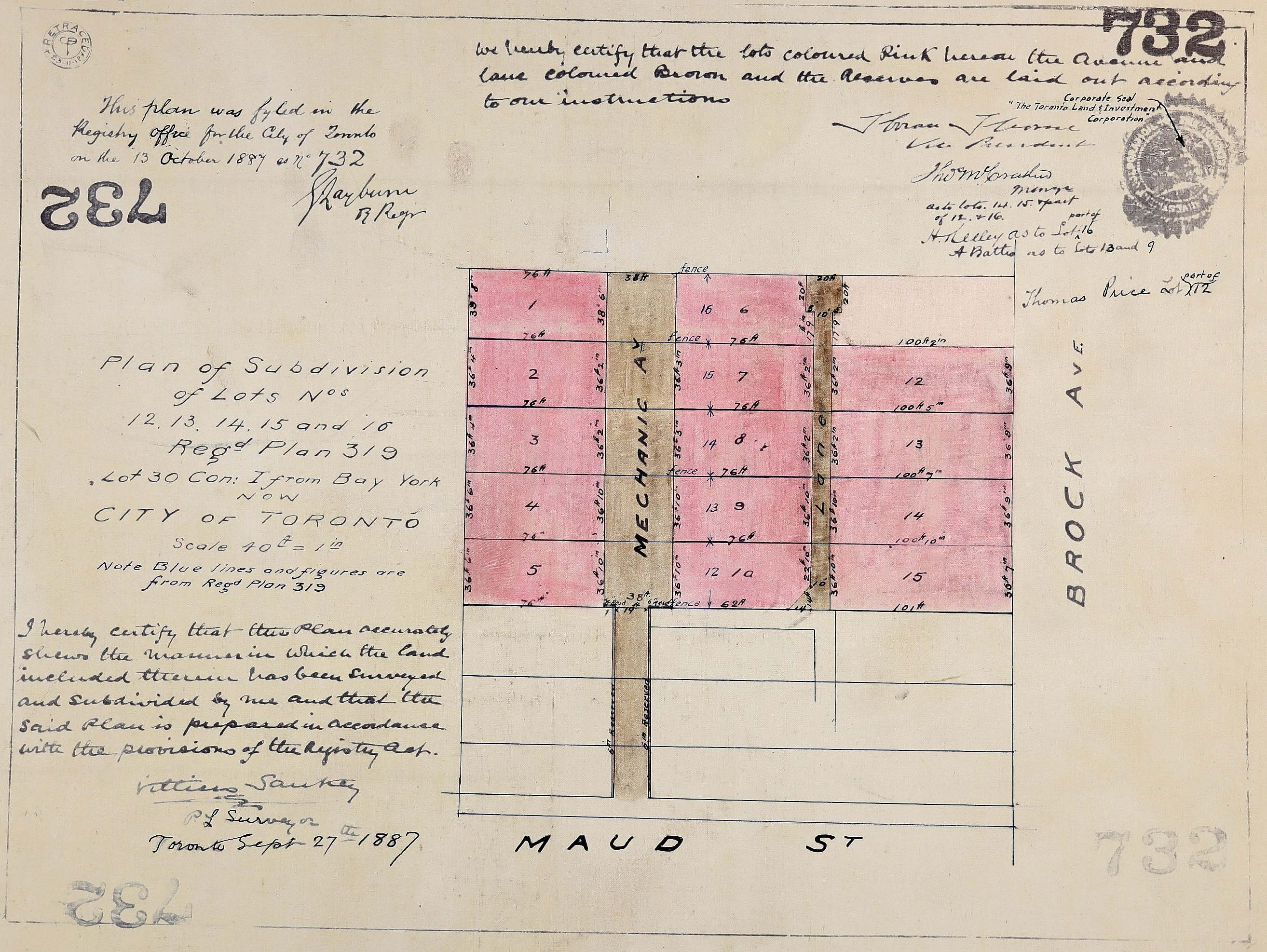
Subdivision plan 732, registered October 13, 1887 - one week prior to Plan 739. (Ontario Land Registry)
Immediately west of Graham's row of semi-detached houses is the terminus of an oddly laid out street called Mechanic Avenue[6]. It first appeared soon after the Toronto Land and Investment Corporation bought up Lots 12 through 16 in subdivision plan 319 in July 1887 from various owners, as well as a 19-foot-wide north-south strip of land connecting those properties to Maude Street. By September they had drafted their plan for subdividing these lands which included the creation of a new road called Mechanic Avenue. No doubt they would have preferred that the southern part of the roadway be wider - especially considering that the 19-foot allowance included sidewalks on either side - but by that point the construction of Graham's houses would have been well under way so buying additional land east of the strip would not have been feasible. Fortunately the city was able to obtain property north of the initial avenue to allow it to continue at full width up to Wyndham Street in 1889.
It should be noted that the word "mechanic" had a different meaning prior to the age of automobiles than it does today. It was applied broadly to all skilled tradesmen as was evident in the Mechanics Wanted classifieds in Victorian and Edwardian newspapers that sought bakers, barbers, bookbinders, blacksmiths, carriage makers, coat makers, electricians, machinists, upholsterers, watchmakers, woodworkers and even photographer’s assistants. As such, it was the perfect moniker for such a working-class neighbourhood.

25 Mechanic Ave. in 1895. Note the wood plank sidewalk. (Ontario Jewish Archives) [7]
Most of the lots in the Mechanic Avenue subdivision plan were developed within a few years as seen in the 1890 Goad's Atlas of Toronto above. Unsurprisingly, it was not long before property owners requested that the city widen the narrow southern terminus. The Works Committee investigated this possibility in the fall of 1902 and reported back that a Mrs. Agnes Rankin had agreed to sell eight feet of her land along the west boundary of Mechanic for eighty dollars which they felt was reasonable. The city concurred and began drafting the necessary by-law to expropriate the property only to discover that a six inch strip along each side of the affected roadway was still in the possession of the Toronto Land and Investment Corporation. When approached about selling the fifty square feet in question, the company demanded eighty dollars, the same as Rankin was charging for her 800-square-foot plot. The Works Committee advised city council that this amount was "exorbitant" and that they should not pay more than twenty dollars. Council agreed and issued an official notice of the intention to widen the street. When no objection was received from local residents a by-law was enacted in November 1903 to proceed with the expropriation, only for planners to run into another major roadblock.


LEFT: 1903 handbill announcing the impending widening of of the southern terminus of Mechanic Avenue. RIGHT: Official survey showing the eight-foot strip of land to be expropriated. (City of Toronto). Records indicate that the street was paved in brick by this time.
When city solicitors approached the owner of the eight-foot tract to make the previously agreed eighty dollar payment they discovered that the property had been sold to a new owner demanding two hundred dollars for the inconvenience. The Works Commission asked Mechanic Avenue owners if they were still interested in proceeding in light of a possible 150% cost increase and the nearly unanimous consensus was that the benefits did not merit the price. Consequently, the widening by-law was repealed in July 1904 and one-way traffic continues to squeeze through the narrow roadway to this day.

The east side of Mechanic Avenue circa 1950s with number 7 on the far right. (Courtesy of Eric Grauer)
NOTES
[1] Isaac Brock was a decorated military officer who was appointed Administrator of Upper Canada in 1811. His military actions in the early months of the War of 1812 earned him a knighthood and he became known as the "Hero of Upper Canada" after his death defending Niagara from an American invasion.
[2] The plan shows measurements in "chains" and "links" which was standard for land surveys at the time. One link is equal to 7.92 inches and 100 links makes up one chain or 66 feet.
[3] While the street name was sometimes written as "Maud", the vast majority of historical records spelled it with an "e" at the end.
[4] Brockton had incorporated as a village in 1881 but the community's subsequent financial struggles led its residents to become part of the city of Toronto just three years later. At the time it was annexed the village spanned from Bloor Street to the railway tracks and from Dufferin Street to Indian Road near High Park.
[5] The definitive resource for neighbourhood boundaries remains Your Guide to Toronto Neighbourhoods which was first published in 1999 and converted into the website neighbourhoodguide.com in 2020. Wikipedia's series of Toronto neighbourhood profiles are also presumably one of the most consulted resources on this topic, for better or worse.
[6] Most historical city directories and city atlases spelled the street name as Mechanics (plural) but official city records have always used the singular version.
[7] Ontario Jewish Archives, item 2014. Finkle (Fanny) Rosenthal and daughter Mollie in front of house at 25 Mechanic Ave., Toronto.


Comments