
THE HOGTOWN GUIDE TO GOAD'S MAPS
GOAD'S FIRE INSURANCE PLANS
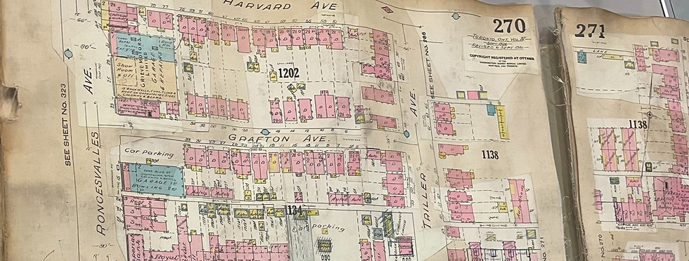
From 1876 until 1973, Charles Goad and successive publishers created large-scale block maps designed to help insurers determine fire risk and corresponding premiums for building owners in communities across Canada. The maps, known as insurance plans, depicted risk factors such as building shapes, heights, and construction materials, which now act as virtual time machines for researchers investigating the history of houses and neighborhoods.
Format
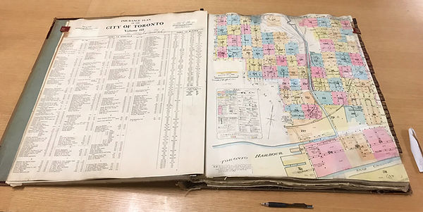
The fire insurance plans originally published by Charles Goad and his successor the Chas. E. Goad Company were a massive 21” by 25” in size and were printed single-sided in portrait orientation. Plans for smaller towns were issued as loose sheets while those for larger cities had the option of being glued back-to-back and bound in hardcovers with leather index tabs affixed to the sheets.
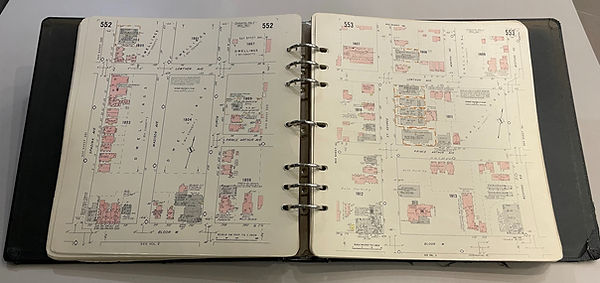
The Underwriter’s Survey Bureau retained this format when they bought out the Goad Company in 1917 and continued its use until 1952. Beginning that year, new editions of plans were published in a 12” x 13” double-sided format with punched holes that were inserted into a 7-ring binder.
Content
Introductory Pages
All fire insurance plans included key plans and symbol keys and most included indexes. Plans for smaller communities would often combine these introductory features onto a single page while plans for large urban centres would use separate pages for the key plans and indexes.
Key Plans
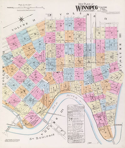
Key plans (or “key sheets” after 1952) were small-scale maps of the entire survey area depicting the boundaries of the individual block plans and their corresponding sheet numbers.
For larger communities, the less developed parts of the city would have sheet numbers reserved for them until they were populated enough to warrant the expense of a survey. With the introduction of the revamped format in 1952, areas that had not undergone significant change since the previous edition were excluded from the plan. The depiction of these excluded areas in the key plan changed over the years: prior to 1952 they were identified by coloured outlines, from 1952 to 1962 with yellow shading and, from 1963 onward, with red shading.
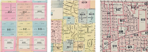
Formatting for unsurveyed areas prior to 1952 (left), 1952-1962 (middle), and after 1962 (right).
Indexes
Indexes could be one of three types:
-
street indexes listed the streets covered in the plan, along with their original names where applicable
-
block indexes listed arbitrary numbers assigned to individual blocks for reference continuity across multiple editions of a plan
-
specials indexes listed high-risk businesses and places of public assembly
Plans with just one or two sheets would typically omit these indexes due to the small amount of area being covered.
All types of indexes were retired upon the switch to the ring binder format in 1952.


left: combined key plan & index page for mid-size plan, right: dedicated index page for large city
Symbol Keys
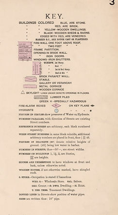
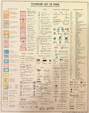
Sample symbol keys from the Goad era (1880) versus the USB / CUA era (1956).
Interpretive legends - called “keys” up until the 1950s - explained the meaning of colors, symbols, and abbreviations that denoted street widths, fire-protection facilities, and the materials, shape, height, placement, and use of buildings, among many other details. Their scope varied significantly from the Goad years when they were relatively minimal to the USB era when they became much more comprehensive. Toronto Archives’ former chief archivist Wayne Reeves has created a compendium of symbol keys used over the years that is particularly helpful when viewing online plans which don't include introductory pages.
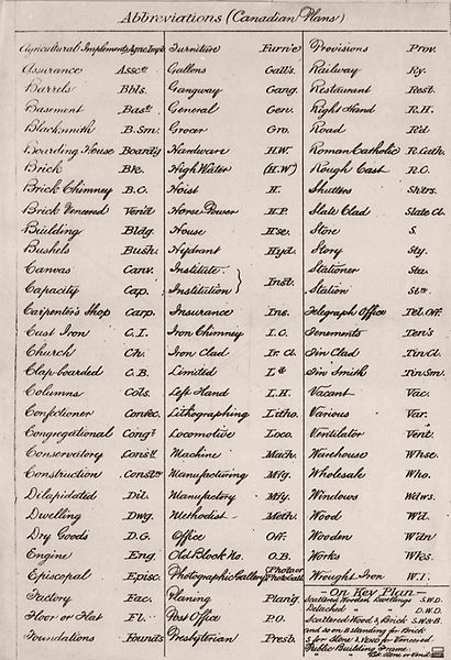
What’s not included in the earlier keys is an index of abbreviations that Goad would use to label buildings’ specific uses or construction details. Fortunately, he left behind the following list in his company records:
Block Plans
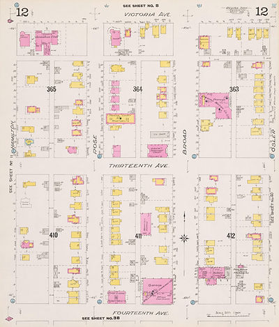
As a general rule, the original-format volumes depicted developed areas of a town at a scale of 50 feet per inch, while a 100-foot scale was used for outlying areas. The small-format volumes introduced in 1952 switched to a 100-foot per inch scale universally. In both formats, the applicable scale is noted on every sheet allowing original and current users to measure a structure's dimensions with remarkable accuracy.
While the amount of symbols used in plans expanded significantly over the years, the shorthand used for basic residential features remained fairly consistent. These are highlighted below as a quick reference guide.
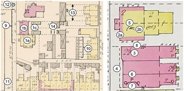
Common Building Content (Residential)
(1) construction material:
-
pink = brick
-
yellow = wood frame
-
grey = wood outbuildings (stables were specifically denoted by an X across the outline of the building)
-
orange (introduced in the early 1910s) = fireproof construction materials
(2) exterior cladding:
-
“RC” = roughcast (stucco)
-
pink outline along yellow building = brick veneer (some later volumes used "V" on pink buildings to indicate that the entire structure consisted of brick veneer, not just the facade)
(3) number of storeys
(4) porch configuration (represented by dashed lines)
(5) interior partition wall (dashed line represents wood or plaster & lath)
(6) roof type:
-
circle = slate
-
P = tar & gravel or composition
(7) mansard roof
(8) side window indicator:
-
one slash = 1st storey, 2 slashes = 2nd storey etc.
-
“none” = no side windows
-
note: front and back of houses are assumed to have windows and so are not depicted
Block Infrastructure Content
(9) street numbers (written parallel to the buildings)
(10) building numbers (written perpendicular to the buildings):
arbitrary numbers used primarily to differentiate buildings on blocks where street numbers were often duplicated
(11) roadway widths (allowance for street, sidewalk and/or boulevard)
(12) fire hydrants
(13) lot lines (often only partial)
(14) block numbers:
arbitrary numbers assigned by the cartographers as a reference point for revision slips and for consistency across new editions[1].
Industrial Plans


Goad also created fire insurance plans for commercial and industrial clients depicting factories, mills and grain elevators among other structures. Examples shown in the above gallery are St. John's Stone Chinaware Company factory in St. John's, Quebec (1895), the New Brunswick Cotton Mills in St. John, New Brunswick (1880), E. B. Eddy pulp and paper plant in Hull, Quebec (1884), a multi-purpose manufacturing complex in Montreal (1880), grain elevators in Winnipeg and Oshawa (1901), and Ogilvie Flour Mills in Winnipeg and Fort William, Ontario (1909).
Revisions
Charles Goad recognized early on that his business’ success depended on his ability to keep plans both affordable and current. Surveying, drawing, etching, printing and hand colouring the pages of a new volume was a labour-intensive process. Therefore, issuing entirely new editions of plans on a frequent basis to capture recent changes would increase his subscribers’ cost significantly, particularly for urban volumes that were comprised of dozens of sheets.
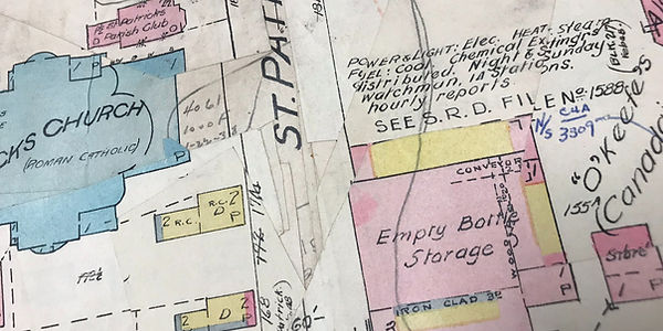
Instead, Goad chose a unique piecemeal approach wherein his staff would draw and print only the buildings that had changed since the previous update then paste these “revision slips” onto the pages of the original edition[2]. Only significant changes merited a slip: minor alterations, changes to sheds, and commercial tenant occupation updates were left as-is unless included within a slip incorporating more major modifications.
The process for revising a plan would begin with Goad’s subscribers themselves as per his instructions in a circular affixed to an early 20th century Toronto volume:
When a new building is erected, or a change occurs affecting a risk, it should be pencilled on the plans as accurately as possible, and advice sent to [the insurance company's] Head Office or General Agent, who should see that their copies are also pencilled, so that in future reference to the same or adjoining property, the previously advised change will be seen at once. Neglect of this simple rule frequently gives rise to expressions of discontent with the careless method of procedure in the office corresponded with, be it H. O., General Agent, or Local Agent, and soon discourages those who, at first, strive to keep the plans closely corrected to date.
The numerous hand-drawn updates found in surviving copies of revised plans suggest this advice was adhered to by many subscribers.
Next, once enough insurance companies had asked for a plan to be revised or expanded, Goad’s staff would review the input they had received from agents in the field, resurvey the applicable area and prepare a collage of individual revisions on what were called transfer sheets. These revisions would be cut out and the slips placed in envelopes according to each plan. If a particular sheet required extensive changes, an entirely new sheet would be printed to replace it.
Subscribers were then notified that a revision was available (for a fee) at which point plans were returned to the Goad office, the revision slips pasted onto the pages, the reprinted pages inserted in place of old ones and the updated copies promptly returned to the customer.
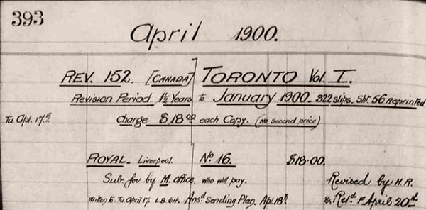
Goad ledger with revisions to subscriber plans. Header includes number of revision slips & reprint pages and cost of revision. Below are customer names and their unique copy numbers.
This process would be repeated multiple times for a given plan until the numerous revision layers interfered with the legibility of the pages. At that point an entirely new edition would be issued and typically offered to existing subscribers at a discount if they ordered within a limited time. As with revisions, subscribers were required to first return their existing plan but this time it would be destroyed or used as paper stock for newer plans that would be printed on the reverse side.
With the introduction of the new plan format in 1952, the scrapbooking approach to revisions was largely eliminated. Modern printing technology, the ring-binder format and a focus on surveying only areas with significant changes since previous editions made it practical and affordable to replace individual pages as needed. The use of revision slips became limited to minor updates like changes to street names.
Familiarity with the specifics of the revision process can provide modern researchers with useful insight into interpreting these historical documents. For one, it allows them to confirm the plan owner's dating of copies in their collection. Secondly, it enables them to narrow down time periods for specific changes in a volume that has been revised many times over its lifespan[3].
Date Slips
While collection holders and the Catalogue of Canadian Fire Insurance Plans are generally very accurate in their dating of insurance plans, they occasionally make mistakes so it never hurts to verify.
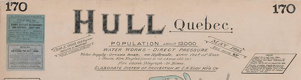

The most reliable method for confirming the year that a copy was revised is to check the date on its introductory page. During the Goad era (up to 1917), original edition dates and revision dates would be noted in the form of a “blue slip” pasted on this page. Each time an edition was updated a new blue slip would be pasted over the former one. During the Underwriters’ Survey Bureau era, these date revision slips were printed on regular paper. For larger volumes, the slips would sometimes also indicate which sheets were entirely reprinted or which new sheets had been added.
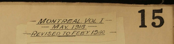
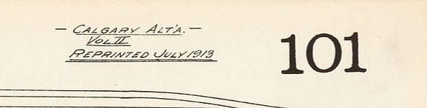

If the title page is missing from a copy, the next best approach is to check the sheet dates at the top right corner of each block plan sheet. The date of the revision will typically be pasted over the original edition’s date and if the page is a reprint or "extension" (a new sheet added to the plan with previously unsurveyed blocks) this date will also be noted.
There are a couple of important caveats to keep in mind when referring to these plan and sheet dates:
-
In rare cases, revised sheets will not have their dates revised. If the sheet dates or plan dates seem earlier than expected, look for revision slips on those pages to see if they have dates or information that is later than the sheet date.
-
When checking sheet dates, check every sheet in the plan. Updated plans are typically a mix of revised and unrevised pages so if you review only a few sheets they may not indicate the latest revision date for the overall edition.
Revision Slips
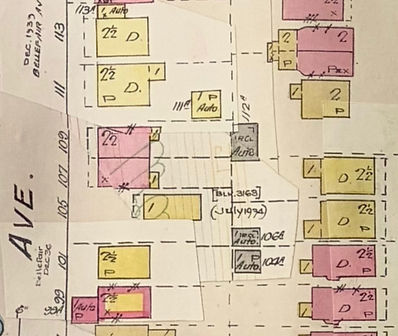
Prior to 1930, plans that were revised multiple times provided no way to determine when a specific revision slip was added. After that year, revision dates were noted on individual slips making it much easier to identify when a change took place. Typically these dates are noted near the street name or block number on each slip as seen in the example above.
When no copies of a revised edition survive, it can be possible to extrapolate that revised version using original transfer sheets of unused revision slips available in select plan collections.


For example, the copies of the May 1951 revision of Toronto volume 3 held by the Archives of Ontario and the Fisher Rare Book Library (at left) do not show the Mount Pleasant Road extension that was completed earlier that year. And while the copy at the Toronto Reference Library (at right) includes the update, much of it is covered by hand-drawn revisions from 1953. Consequently, none of the three available copies depict how this significant development first transformed the neighbourhood. However, the Toronto Reference Library holds the actual April 1951 transfer sheets for this volume, allowing researchers to deduce this missing information[4]. This is seen in the middle image where the revision slip has been digitally inserted onto the original page to depict the neighbourhood in the time period between the two other versions.
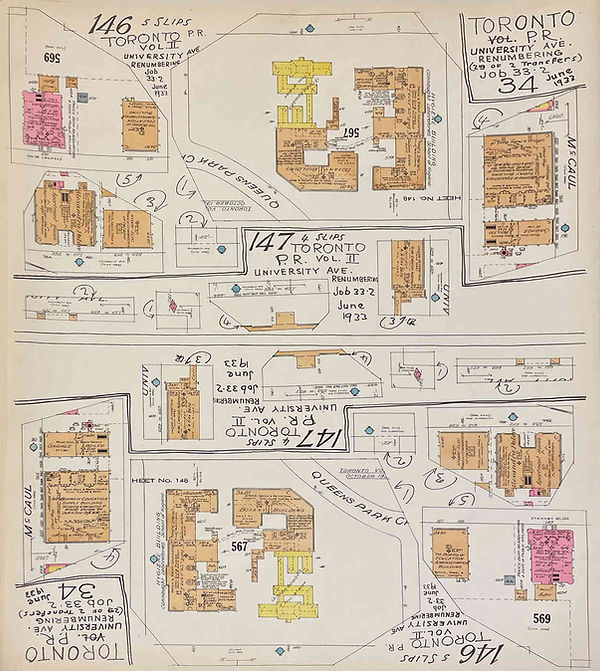
Sample revision slip transfer sheet.
The anatomy of a transfer sheet is fairly straightforward: Each cluster of revision slips is labelled with the corresponding plan name, the plan’s sheet number (in large bold numerals) and the total number of slips created for that sheet. The sheet above is a bit of an anomaly in that one group of slips are printed twice on the sheet (5 slips for sheet 146 and 4 slips for sheet 147 of Toronto volume 2). Note that slips for a single plan page were sometimes spread across multiple transfer sheets while, conversely, multiple plans or multiple places were sometimes printed on a single transfer sheet.
Instructions on how to locate holdings of surviving revision slips can be found in the COLLECTIONS section of this Guide.
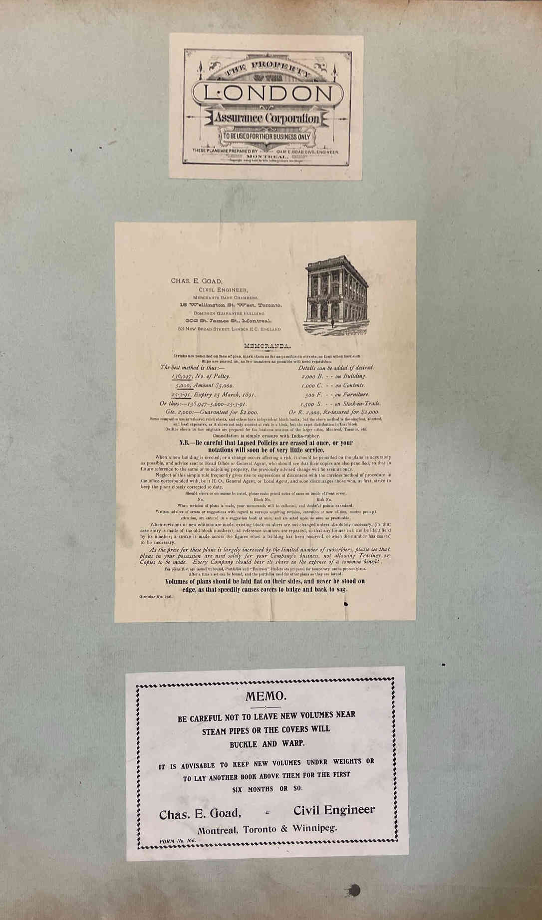
Use and care instructions and an owner identification sticker found inside the front cover of a 1907 Toronto volume.
Notes
CONTENT
[1] For Toronto volumes 1-9, block numbers are random numbers between 2 and 4 digits. Beginning in the 1930s, a more formulaic numbering system was implemented for brand new volumes i.e. volumes 10 and up. This is noted in the universal abbreviation index for all new plans after 1950.
REVISIONS
[2] Goad used the terms “revision slips” and “correction slips” interchangeably. I have opted for the former for the sake of consistency.
[3] The 1912 edition of Toronto volume 7, for example, was revised 14 times over a span of nearly 40 years.
[4] In this particular case, the transfer sheets reveals that the road extension update also applied to volumes 5 and 7, despite the fact that the Catalogue of Canadian Fire Insurance Plans doesn’t note any revisions to volume 7 around this time.
Illustration Credits
FORMAT
-
original plan format: Peter Marshall
-
ring binder plan format example: Peter Marshall
CONTENT
-
1906 Winnipeg key plan: Library and Archives Canada
-
key plan reserved sheet number examples:
-
Toronto plan volume 8, 1916: Library and Archives Canada
-
Toronto plan volume 9, 1956: Peter Marshall
-
Toronto plan volume 6, 1965: Peter Marshall
-
-
index examples:
-
1907 Orangeville key plan and index: Library and Archives Canada
-
Vancouver plan index, 1897: Library and Archives Canada
-
-
symbol key examples:
-
Toronto plan volume 1, 1880: Toronto Archives via "Goad's Atlas of the City of Toronto"
-
Toronto plan volume 9, 1965: Peter Marshall
-
-
abbreviations legend: Charles E. Goad Company fonds. Library and Archives Canada microfilm reel H-1815, image 182 at Canadiana.ca.
-
block plan of Regina, 1907 revised to 1913: Library and Archives Canada
-
industrial plan examples
-
manufacturing complex in Montreal: Library and Archives Canada
-
New Brunswick Cotton Mills: Library and Archives Canada
-
E. B. Eddy plant: Library and Archives Canada
-
St. John's Stone Chinaware Company factory: Library and Archives Canada
-
grain elevators in Winnipeg and Oshawa: Library and Archives Canada
-
Ogilvie Flour Mills in Winnipeg: Library and Archives Canada
-
Ogilvie Flour Mills in Fort William, Ontario: Library and Archives Canada
-
REVISIONS
-
header: Peter Marshall
-
Charles Goad ledger: Charles E. Goad Company fonds. Library and Archives Canada microfilm reel H-1815, image 257at Canadiana.ca.
-
plan date slip examples:
-
Hull plan: Library and Archives Canada
-
Montreal plan volume 1, 1918 revised to 1940: Bibliothèque et Archives nationales du Québec
-
-
sheet date revision slip examples:
-
Montreal plan volume 1, 1918 revised to 1940: Bibliothèque et Archives nationales du Québec
-
Calgary plan volume 2, 1911 revised to 1913: Library and Archives Canada
-
Toronto plan volume 7, 1912 revised to 1915: Library and Archives Canada
-
-
revision slips with dates (from Toronto plan volume 9, 1939 sheet 923): Peter Marshall
-
revision slip transfer sheet: Peter Marshall
-
use and care instructions from Toronto Reference Library copy of Toronto plan volume 5, 1907 revised to 1914: Peter Marshall