
THE HOGTOWN GUIDE TO GOAD'S MAPS
GOAD'S TORONTO PLANS AND ATLASES

With nearly two dozen volumes published and revised at random intervals over nine decades, the scope of fire insurance plans available for Toronto is comparable to that of some provinces. Combine this with 14 atlas editions issued over 35 years and it can be confusing for property researchers to know where to start. The following Toronto-specific information supplements the general background in this Guide to help readers determine which maps apply to a given property and where they can be found today.
Toronto Maps History
Fire Insurance Plan Timeline

Final boundaries of Toronto volumes in 1973 compared to 1880 original volume (in red).
As with other large urban centres, Charles Goad's Toronto fire insurance plan (singular) was divided into multiple parts that he called "volumes". This term traditionally denotes a single component of a collective body of work wherein updates consist of issuing new versions of all components. The practice of most archives and libraries to catalogue their city plans chronologically rather than by volume implies that this traditional definition applies to these maps as well. But that isn't the case.
These volumes should not be viewed as components of a comprehensive city plan, but as a loose collection of related yet independent neighbourhood plans.
The publication and revision of Toronto insurance plan volumes was driven not by the growth of the municipality as a whole but by the growth of specific sections and by the addition of new areas as the city annexed neighbouring communities. As a result, the publication of the first and final “volumes” for Toronto and its environs was separated by a span of nearly a century, with some early editions being updated dozens of times before the first appearance of later ones. Furthermore, the coverage of many editions extended beyond the city limits and into adjacent townships. Therefore, these volumes should not be viewed as components of a comprehensive city plan, but as a loose collection of related yet independent neighbourhood plans. This distinction becomes apparent when tracing how the 22 volumes were rolled out over a span of 93 years.
Defining "Toronto"

Toronto annexations between 1883 and 1967.
Toronto began as a territory of slightly less than 6,200 acres when the former town of York was renamed in 1834. Then, beginning in 1883, the city gradually annexed numerous adjacent communities from the surrounding Township of York, turning former suburbs such as Parkdale, Yorkville and Riverdale into neighbourhoods within the growing metropolis. This piecemeal expansion came to an end with the establishment of the 1967 city boundaries that stretched from Scarborough to Etobicoke and from the lake to North York and which remained in place until 1998. In that year, the province amalgamated the city with the remnants of York Township and the former boroughs of Etobicoke and Scarborough to create the current megacity of Toronto. Ever since then, the 1967-1998 iteration of the city is commonly identified as the “former City of Toronto”.
Volumes 1 & 2 (Chas. E. Goad)

The original Goad's insurance plan volume for Toronto, issued in 1880.
When Charles Goad published his first Toronto volume in 1880, the city was bounded by the Don River on the east, Dufferin Street to the west and Bloor Street at its north end, with a panhandle between the Lake Ontario and Queen Street East extending to the Beach(es). Within this area, the original edition of Volume 1 covered part of what Goad termed the “Central District” of the city, stretching north to Bloor Street, east to Cherry Street and west to Strachan Avenue. It is the oldest surviving insurance plan of the city after the 1858 Atlas of the City of Toronto[1].
Two years later, Goad issued the first edition of volume 2 covering the areas immediately east and west of the first volume. Although no copies of this edition remain, there are copies of a revised version from 1889 which reveal the original's coverage area and its role as a companion to a revised volume 1 [2]. The Toronto Reference Library has a complete copy of the combined 1889 revision that includes the introductory pages but the non-sequential order that those pages appear online[3] makes it very difficult to distinguish which sheets belong to the 1882 original and which to the 1889 revision. Without this distinction, the content of those sheets appears contradictory. The following clarifications will help researchers effectively utilize this rare Victorian-era volume.
Combined Key Plan

The combined key plan for volumes 1 and 2 doesn’t distinguish between the areas covered by each volume so boundaries have been added to the version above. Note that the sheets bordered by the dashed line were added to volume 2 in its 1889 revision and so would not have been part of the original edition.
The original volumes indicate Goad’s lack of a long-term vision for mapping the growing city.
A notable difference between the two volumes is the scale used for the corresponding sheets: the surveys in volume 1 characterized by the small, coloured boxes are drawn at a 50-foot scale while the ones represented by the larger coloured boxes that make up the majority of volume 2 are drawn to a 100-foot scale.
Both volumes indicate Goad’s lack of a long-term vision for mapping the growing city. The boundaries of volume 1 are a patchwork of secondary streets which give it a confusing irregular shape compared to later volumes that employed major roadways, railway lines and rivers as more streamlined and intuitive volume borders. In a similar vein, the coverage area of volume 2 is tacked on to either side of volume 1 rather than encompassing its own distinct territory. This absence of foresight lead to volume 2 having to be rezoned just a few years later when additional volumes were added to the collection.
Volume 1 Contents (1880 revised to 1889)
The first 54 sheets of this combined volume consist of the original volume 1 sheets with subsequent revision slips pasted onto them:


There does not appear to have been a street index issued with the original volume 1, unlike all subsequent editions.
Volume 2 Contents (1882 revised to 1889)
The remaining sheets in the combined volume make up the first edition of volume 2 with subsequent revision slips affixed to them:


Riverside

West Toronto Junction

Although this Toronto Junction plan is included in the only online copy of the combined Volume 1 and 2 [4], the town's streets are not included in the combined street index unlike the Riverside plan. Furthermore, the plan's September 1892 revision date (from a June 1889 original) is three years later than the latest updates indicated in the blue slips in the combined volume. It’s therefore possible that its inclusion in this copy was a unique circumstance.
Volumes 3-6 (Chas. E. Goad)

The Catalogue of Canadian Fire Insurance Plans lists only volumes 1, 2 and 6 as being published prior to 1900. However, after obtaining a reproduction of the 1897 edition of volume 6 from the British Library, a key map for the entire city was discovered in its front matter which indicated there were six volumes in existence at that time and that they used sequential sheet numbering. Approximate publication dates of the lost first editions were then determined based on clues in other volumes.
It's very likely that all of the above editions other than volume 6 were published prior to 1895 which is why they are not included in the British Library's holdings of Canadian copyrighted publications which begins in that year.
The same city key plan also includes insurance plans for the village of East Toronto and the town of West Toronto Junction. These would be the 1897 East Toronto plan (which references the adjacent Toronto volume 6) and the 1889 Junction plan mentioned above in the description of the combined volume 1 and 2 from that year.
Volumes 7-9 (Chas. E. Goad Company)
Following Goad’s death in 1910, the Chas. E. Goad Company issued the first edition of volume 7 in 1912 while the firm was under contract to the Canadian Fire Underwriters’ Association. The CFUA introduced a more regimented process that included a regular revision schedule for Canadian plans in general and the introduction of volume-based centennial sheet numbering for new Toronto surveys in particular[5].
The first editions of volumes 8 and 9 followed in 1916, with the latter incorporating the old East Toronto plan.
Volumes 10-22 (USB and CUA)

1970 key plan to Toronto volumes with revision slip added for the 1973 publication of volume 22.
The volumes issued during the Goad Company's tenure had extended the range of the Toronto plan slightly beyond the city's boundaries and the CFUA’s heir, the Underwriters’ Survey Bureau, expanded this initiative, dividing up all of Scarborough, Etobicoke, North York, York and East York into new volumes with pre-assigned numbers. The new coverage areas had more regular geometric shapes as their boundaries were based on major roads, railways and rivers. The majority of these first editions also covered much larger areas than earlier volumes with the intention of surveying only the most developed part of the territory at first then increasing coverage in subsequent editions as warranted. As a result, the volume boundaries would remain fixed rather than expanding with each new edition.
It was only in 1959 that volumes 10 and 11 – the lowest numbers in the USB’s expansion – were finally published.
Oddly, the volumes were not released in numerical order but by the order of their coverage area’s development. Thus, volumes 15-16 covering central and east Etobicoke were released first in 1935, volumes 12-14 covering the west end and south Etobicoke were issued in 1937 (incorporating the former independent plans for Toronto Junction and Mimico), volumes 17-18 were originally published in 1946, volume 19 – an anomaly covering the Port Credit area in what is now Mississauga – in 1952, and volume 20 in 1955. It was only in 1959 that volumes 10 and 11 – the lowest numbers in the USB’s expansion – were finally published.
In 1965, the Canadian Underwriters’ Association succeeded the USB and issued volumes 21 and 22 in 1969 and 1973, respectively, before ending the publication of fire insurance plans in Canada.
Atlas Timeline
Unlike Toronto insurance plans, the first two editions of the Toronto atlases required only a single volume to cover almost the entire former city. This was possible because the atlases utilized scales as small as 1,000 feet to the inch for the outlying areas in which buildings were depicted as little more than black dots. As the city became more developed, the scale employed for suburbs and annexed villages became larger which necessitated more pages to cover the same territory. Consequently, the third and final edition in 1910 required the atlas to be divided into three separate volumes.
Because the atlases ceased publishing after a 1923-24 revision of the 1910 editions, their coverage area did not expand much beyond the former city, unlike insurance plans which went on to cover most of Etobicoke, Scarborough and North York prior to being discontinued in the 1970s.
The following key plans from each edition show the city boundaries at time of publication and indicate the different scales used to cover the city versus the outlying suburbs.

1884 atlas key plan composite with 1883 city limits in red and final city limits in black.
In the original 1884 edition there are four key plans found on plates 1, 36, 37 and 38 which have been composited into a single map above. The red outlines and red numbers represent the plates in the atlas wherein:
-
the smallest plates are drawn at a scale of 100 feet to 1 inch
-
the medium-sized plates at drawn at 200 feet to 1 inch
-
the largest plates just outside the city limits use a 300-foot scale
Regions beyond this were not depicted on separate plates, appearing only on these 1,000-foot scale key plans. Coloured zones represent city wards as of 1883 when Goad completed his surveys. These municipal boundaries became outdated just two months after the atlas’ January 1884 publication when Toronto annexed Brockton and Riverdale necessitating the addition of two more wards. Note that although the Toronto Islands are not shown on these key plans, they can be found on plate 30 in the atlas.

1890 atlas key plan composite with period city limits in red and final city limits in black.
The second edition released in 1890 contained key plans on plates 1, 48, 49 and 50. A larger scale was employed for the former outlying areas that had now been annexed by the city, as well for as adjacent suburbs. Coloured shading was used to represent the boundaries of the atlas plates rather than the city wards (like in key plans found in fire insurance plans), while the Toronto Islands were once again found on plate 30.

1910 atlas key plan with period city limits in red and final city limits in black.
By the time of the 1910 third edition, the city and most of the suburbs had been developed to the point where they had to be drawn to a larger scale than previously which meant there were now too many plates to fit in a single volume. Consequently, the core of the original 1884 edition became volume 1 while volumes 2 and 3 covered the former suburbs and even spilled into neighbouring townships of Etobicoke, East York, and York. Each of the new volumes contained their own two-page key plans.
Plates in the “congested part of the city” were drawn at 100 feet to the inch while the remainder of the atlas used a 200-foot scale except for four plates that covered the outlying areas of volume 2 which were 300 feet to the inch.
Evolving Street Names & Numbers

Don’t be surprised if you locate your century-old home in a plan or atlas only to find it labelled with a different house number and/or street name than it currently bears.
Just as Toronto’s borders were subject to change in its early years, so were its street names. A primary reason was the relabeling of streets in newly annexed communities which duplicated street names already in use within the city. Another common factor was the linking of two aligned streets previously separated by a stretch of undeveloped land. Once the streets were connected it no longer made sense to treat them as separate roads and so one would typically assume the name of the other. Goad’s plans and atlases did not always reflect these name changes as soon as they occurred so they should not be relied upon for accurate dating. Instead, see Wayne Reeve’s comprehensive database of Toronto street name changes.
In a similar fashion, street numbers had to be adjusted occasionally during Toronto’s early years as sparsely populated blocks filled up with buildings or two separate roads were connected and reclassified as a single street. 1889 saw a particularly extensive renumbering initiative across the city which was captured in the insurance plan’s combined volume 1 and 2 from that year which indicates the previous numbers alongside the new numbers for all affected buildings.
Locating a Property
Fire Insurance Plans
Goad Era Editions (1880-1917)

Because the boundaries of Toronto volumes were continually evolving during the Goad era it’s not possible to strictly define these editions by their geographical coverage. Fortunately, though, the University of Toronto has plotted their collection of volumes from this period on a geospatial map. This interface allows users to type in an address to discover many of the early editions which covered that property.
While this tool is extremely helpful and simple to use it should only be considered as a starting point. As extensive as UofT's collection of plans from this time may be, it is by no means complete. To determine the true number of editions that apply to a property, refer to the following PDF key plans for the volume you've determined is applicable to its address.
All Editions (1880-1973)

Final boundaries of Toronto plan volumes as of 1973.
For a complete list of surviving editions from all years, use the map above to determine which volume may include your property then view that volume's key plan index using the linked list below.
These indexes contain key plans for each edition of a volume as well as for plans of independent towns that preceded it. They will confirm whether a given edition includes your property as a volume’s early coverage area usually differs from the final one depicted in the map. Furthermore, volumes covering the former North York, Scarborough and Etobicoke surveyed only a small portion of the area assigned to them.
Once you've determined which editions apply to your property, you're ready to track down a copy of those editions using the tips in COLLECTIONS below.
City Atlases

All editions of the Toronto atlases are available online in a geospatial map provided by the University of Toronto that allows users to type in an address and quickly discover which plates of which editions pertain to that location.
Collections
Fire Insurance Plans
Toronto is fortunate to have half a dozen institutions with substantial repositories of fire insurance plan volumes for the city. While the online versions are naturally the easiest to access, they represent less than 20 percent of the holdings available to researchers who are willing to put in a little legwork.
Digitized Copies
Library and Archive Collections

The Toronto Public Library offers a handy finding aid for digitized Toronto insurance plans. Just remember that only editions with expired copyright (generally before 1917) have been digitized.
The finding aid links to online collections from four Toronto institutions:
-
Toronto Public Library: complete plans in PDF format that include non-cartographic matter i.e. title pages, indexes
-
University of Toronto Map and Data Library: block plans posted in the geospatial format mentioned above
-
Library and Archives Canada: complete plans presented in a built-in viewer
-
Toronto Archives: block plans hyperlinked to key plans
In addition, there are links to Nathan Ng's “Goad’s Atlas of the City of Toronto” blog which shares digitized plans from the Toronto Public Library and Toronto Archives in a more user friendly fashion by linking block plans to their key plan (which the TPL site does not do) and including non-cartographic matter (which the Toronto Archives site omits). The scan quality of the TPL plans is also better than the PDFs provided on the library's own site.
Be aware that this TPL finding aid contains a few errors which may cause some confusion:
-
incorrect classification of the 1880 volume 1 plan as an atlas
-
incorrect dating of the 1889 combined volume 1 & 2 as 1892 (due to a similar dating error by the linked source)
-
incorrect dating of a 1917 revision of volume 1 as 1909 (due to a similar dating error by the linked sources)
-
incorrect dating of a 1914 revision of volume 2 as 1910
-
incorrect labelling of the 1903 Toronto Junction plan as Toronto volume 12
Hogtown House Histories Collection

In 2026 the TPL finding aid added yours truly to their listings. The Hogtown Fire Insurance Plan Collection was created that year to digitize and post very rare editions of Ontario plans such as the nine editions of Toronto plans held exclusively by the British Museum and other early plans previously available online only as black and white scans.
Hardcopies
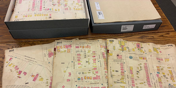
If you’re looking for colour copies of editions that are still claimed to be in copyright (i.e. less than 90 years old), then you’ll have to rely on hardcopies. The Canadian Catalogue of Fire Insurance Plans lists which original Toronto volumes are held by which institutions, although it has been found it to contain numerous errors and omissions, many of which are corrected in the key plan indexes above. Copies of this publication are available for viewing at the Toronto Archives and the Toronto Reference Library.
Within the city, hardcopy plan collections are held by Toronto Archives, Toronto Reference Library Special Collections Centre, University of Toronto Map & Data Library, Thomas Fisher Rare Book Library, York University Archives and Archives of Ontario. Outside of the city, the Western University Archives and Library and Archives Canada possess the most extensive repositories of Toronto plans.
Microform Copies
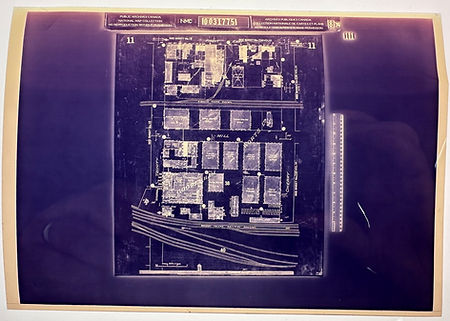
The Toronto Archives' hardcopy volumes are not available to the public so if you don't want to pay them for professional scans of editions not posted online then you'll need to settle for their black and white microfilm versions. (Ignore the fact that the reels are all mislabelled as atlases.)
At the Toronto Reference Library, the Humanities and Social Sciences department holds copies of microfiche provided by Library and Archives Canada. Unfortunately, each fiche holds only one full-size plan sheet (as shown above) which means a microfilm scanner can only view a quarter of the page at a time making this antiquated medium even more awkward to use. The library’s index of its microform plan collection is available here.
Atlases
Toronto atlases are out of copyright and are therefore all available in digital colour. See the Toronto Public Library's index of digitized atlases for links to multiple institutions that have posted their collections online.
Notes
HISTORY
[1] There was an earlier fire insurance plan published by Goad’s American predecessor D. A. Sanborn in 1875 but no copies are known to exist.
[2] The 1889 revision has numerous indications that the two volumes were intended to be paired:
-
the blue revision slip pasted onto sheet 1 of volume 1 indicates revision dates for both volumes
-
the blue slip on sheet 56 of volume 2 was specifically titled “Vols. I & II”
-
the key plan on sheets 56 & 57 includes sheets for both volumes
Despite this, the two parts were published separately as indicated by the handwritten copy numbers on the Toronto Reference Library’s copy of volume 1 (sheet 1) and volume 2 (sheet 57).
[3] The library's copy is posted on their own web site and on the blog “Goad’s Atlas of the City of Toronto”.
[4] The copy posted by the Toronto Public Library is the same copy as posted by the UofT Map and Data Library as evidenced by the same copy number (32) handwritten on sheet 1. The 2002 Catalogue of Fire Insurance Plans in Canada states that the only other surviving copy is at Library and Archives Canada but that no longer appears to be the case so it's not possible to corroborate its inclusion of the West Toronto Junction plan.
[5] When the CFUA's successor the Underwriters' Survey Bureau introduced their smaller plan format in 1952 it retroactively applied the centennial sheet numbering system to the new versions of volumes 4 through 6 as well. Volume 1 kept its double digit numbering and the contents of volumes 2 and 3 were never renumbered because no editions were published after the new format was introduced.
Illustration Credits
PAGE HEADER
-
title page of Toronto fire insurance plan: Peter Marshall
HISTORY
-
key plan from 1880 Toronto fire insurance plan volume 1: Toronto Public Library via “Goad’s Atlas of the City of Toronto”
-
pages from 1889 Toronto fire insurance plan combined volume 1 & 2: Toronto Public Library via “Goad’s Atlas of the City of Toronto”
-
Toronto key map from 1897 fire insurance plan volume 6: Peter Marshall
-
Toronto key map from Toronto Reference Library Special Collections copy of Volume 22: Peter Marshall
-
Toronto atlas timeline illustrations:
-
1884 and 1890 key maps: Library and Archives Canada
-
1910 key map: Toronto Public Library via “Goad’s Atlas of the City of Toronto”
-
-
Toronto annexation map: Toronto Archives
-
street name and number changes on Toronto plan volume 1, 1889: Toronto Public Library via “Goad’s Atlas of the City of Toronto”
COLLECTIONS
-
Western University collection: Peter Marshall
-
Toronto Reference Library microfiche: Peter Marshall