
Goad's Plans Collections
- Peter J. Marshall

- Jun 1
- 10 min read
Updated: 3 days ago
The Hogtown Guide to Goad's Maps
ABOUT | HISTORY | FIRE INSURANCE PLANS | CITY ATLASES | COLLECTIONS | TORONTO MAPS

While finding copies of Goad's city atlases is simple since every edition is available online, collections of fire insurance plans have only been partially digitized. That means it will take some legwork for ardent researchers to track down all of the available editions that pertain to a given property.
Fire Insurance Plans
Hardcopies

The authoritative list of Goad's fire insurance plans (and city atlases) published in Canada is the Catalogue of Canadian Fire Insurance Plans 1875-1975 issued in 2002[1].
Authors Lorraine Dubreuill and Cheryl A. Woods meticulously recorded details of surviving hardcopies they found in 122 public collections across the country and in the voluminous holdings of the British Library then cross referenced them against Charles Goad’s original records which are the only evidence of many editions that no longer exist. The book also includes plans and atlases published by Goad's competitors.
For each map, the catalogue provides the date of original publication or revision, the scales used, the number of sheets and, most importantly, the location of the surviving copies.

Sample catalogue listing (with incorrect description of plans as "atlas").
The catalogue's format is fairly straightforward but a couple of headings can use some explanation:
“LEDGER” indicates the number of copies originally printed per the Goad Company ledgers (described in the HISTORY section)
“HELD AT” indicates the institutions that have a copy of the plan, using abbreviations that are spelled out at the start of the catalogue. A few caveats about this information:
if there is a number in parentheses following the institution’s abbreviation then the copy they hold is incomplete and they only posses the number of sheets indicated
If this field is left blank or contains codes not included in the list of abbreviations such as “Doc1”, “RB1” or “C#42” then are no surviving copies
In my experience, the sources identified as holders of a plan sometimes don’t actually have the listed volume

Listing for edition with verso sheets and revision slips available.
Part of this catalogue’s tremendous value to researchers is its inclusion of surviving “verso” sheets. These sheets are the outcome of publishers’ efforts to reduce costs by printing new plans on the reverse of unsold older plans. In many instances where no complete copy of the older plan exists, these verso copies make up the sole surviving version. Also helpful is the catalogue’s inclusion of unused sheets of revision slips held by some institutions. Both types of sheets are occasionally only available in black and white which suggests that publishers held off on the laborious task of hand-stencilled colouring until demand for the pages required it.
What’s not particularly useful is the catalogue’s (semi) chronological filing of entries by place rather than volume. This is fine for single-volume towns but not for urban centres that had multiple volumes published and revised independently of each other over the years. Searching for a property in these city plans requires scanning dozens of entries for the corresponding volume. In the case of the Toronto plan, there are 20 pages of listings for its 22 different volumes which is why I’ve created separate volume indexes in the TORONTO MAPS section.
Also unhelpful is the inaccuracy of much of the information. If the listings for Toronto plans are anything to go by, this book is rife with incorrect edition dates and sheet numbers as well as repository information, often stating that copies are held by institutions that don't actually have them or even overlooking some editions entirely.
Unfortunately the catalogue has not been digitized and physical copies are hard to come by. If you don’t have easy access to a copy in your town, I’ve provided the index of the 1,600+ places covered by the book here. If the community you’re researching is included in that list then feel free to contact me and I’d be happy to also provide a copy of the related entries.
Depending on where you live, visiting the institutions that hold these copies may also be a challenge. In these cases, find out if they offer paid reproduction services or have a list of local researchers that can photograph the maps for you. There are three repositories in particular that are of particular value to any serious researcher: Library and Archives Canada, Western University and the British Library.
Library and Archives Canada
Canada's national archive has digitized most of their extensive collection prior to 1920 but they keep a tight lid on plans after that date to mitigate copyright infringement. This means that a significant amount of plans identified as Library and Archives Canada holdings in the Catalogue of Canadian Fire Insurance Plans won't even appear in their database. Instead, you'll need to contact them directly for instructions on how to view these plans, many of which have actually passed the 90-year limit for copyright.
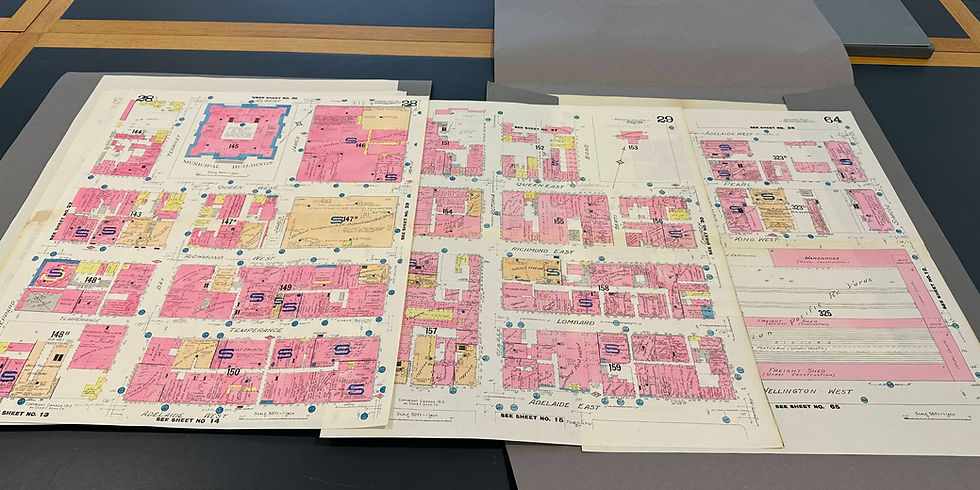
Western University Map and Data Centre
Next to the national archives, the largest repository of plans is probably Western University's Map and Data Centre at the D. B. Weldon Library thanks to its past association with the most prolific private collector of fire insurance plans in Canada, Edward Phelps. While their collection is largely limited to plans dated 1950 and later, their Ontario holdings span the entire history of publication for that province.
British Library
The origin of this overseas collection lies in an 1842 British law requiring that one copy of all works published in the British Empire be deposited at the British Museum for copyright enforcement purposes. Canadian publishers were initially lax in following the law, focussing instead on their country’s own requirement to provide two copies to the Copyright Office in Ottawa which was administered by the Minister of Agriculture. The office would then file one copy in the Library of Parliament and retain the other in the Copyright Office. In 1895 the Canadian copyright act was amended to require a third copy be deposited in the British Museum and remained in force until 1925.
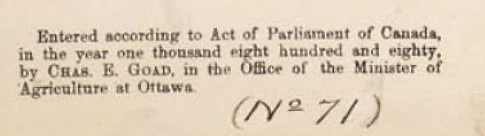
Copyright notice from 1880 Toronto plan.
It appears that Goad’s general practice was to amass a number of plans, bind them together cheaply and then copyright the collection of plans as one book. This way, rather than pay thirty or forty individual copyright fees, Goad would only pay one fee for the thirty or forty bound items. Goad’s attempt to circumvent the copyright fees probably explains why some plans were not forwarded to the British Museum. Furthermore, Goad did not register the individual revision slips that were pasted onto original editions, only the pages that were revised in their entirety.
The books were transferred to the British Library’s Map Library in the 1920s at which point the staff undertook the task of separating and cataloguing of the plans. Meanwhile, the official collections of early copyright materials held in Canada were obliterated. A fire in the Parliament Buildings in 1916 and in the Library of Parliament in 1953 destroyed many of the works deposited there and many more were lost in temporary storage before the remainder were sent to the National Library - now Library and Archives Canada - where they are presently stored. Around the same time, the vast majority of the deposits in the Copyright Office were deliberately destroyed when the bureau moved to smaller premises in the 1930s and determined the copies to be of no value. As a result, the British Library collection contains more Goad plans for the period 1895 to 1917 than does Canada's national archives.
Toronto plans at the British Library.
Online Copies
Once you've determined which institutions hold copies of a plan, check their website to see if any editions have been digitized. If so, the selection will likely be limited due to either a lack of resources or concern about copyright infringement for editions less than 90 years old. (More on that below.)
Microform Copies
While microfilm and microfiche provide low quality greyscale replicas of original hardcopies, they are sometimes the only options that are available locally. Check with your local library, history museum or municipal archives.
Verisk Enviroscan

For researchers with more money than time, digitized colour photocopies of fire insurance plans can be purchased from the most recent successor to the original publishers, Verisk Canada, through their Enviroscan service. As of 2026, the cost is $50 to research which plans and editions apply to your address and which specific sheets within those plans cover the area within a 250 metre radius of the address. Purchasing the digitized sheets costs $110 per edition in Ontario and $125 in other provinces. Payment is by cheque or wire transfer.
Copyright
The successors to the publishers of Goad’s fire insurance plans have claimed that the copyright for these works is valid for 90 years after publication. While researchers using the materials for personal purposes are not subject to any limitations on their reproduction, they may still be interested to know why institutions vary dramatically in their adherence to the 90-year claim. The full explanation is provided in a lengthy 2021 journal article by preeminent authority on copyright and archival collections, Jean Dryden[2]. The short answer that follows is a synopsis of Dryden’s analysis.
Increasing environmental regulation in the 1980s lent new value to fire insurance plans that the IAO had sold off. Thus, they asserted their claim to copyright in 1989.
Increasing environmental regulation in the 1980s lent new value to the fire insurance plans that had been discontinued by the Insurance Advisory Organization in 1974. Commercial landowners were now required to clean up contaminated sites before development which meant that the historical land use chronicled in the old plans was valuable information not available anywhere else. The only problem for the IAO was that they had sold off their inventory. Obtaining reproductions of those plans from the libraries, archives and museums (LAMs) that now possessed them was fairly easy but stopping potential paying customers from also obtaining free copies at these public repositories was another matter. Thus, the IAO asserted its claim to copyright in 1989.
In early 1993 the association sent letters to LAMs holding fire insurance plans to ask for their cooperation in preventing users from making reproductions for commercial purposes. Later letters were less cordial; a 1997 missive from the IAO’s lawyers threatened to “resort to any necessary legal action to prevent any organization or person from making copies of or making use of the IAO’s maps and plans without its permission.”
After protracted discussions with various institutions, the association reached an agreement with the Archives of Ontario in 1995 wherein the IAO would not hold the Archives liable for improper use of the plans by users provided they agree that:
the term of copyright in each plan would be 90 years after the most recent date on the plan
statements would be added to their plan inventory advising users to contact the IAO if they intended to use copies less than 90 years old for commercial purposes
The 90-year term was based on an assumption that the typical author of the plans was 40 years old at the time the work was created, that the author had lived to be 80 years old, and that 50 years had elapsed since the author’s death which was the duration mandated by Canadian copyright law.

This copyright notice stamped onto on a plan volume from 1965 is highly misleading. It was likely added in 1997 to reflect the IAO's 90-year claim in which case the 1907 cutoff date was obsolete within a year.
To assist other institutions negotiating with the IAO, the Archives of Ontario informed them of the arrangement they had struck. While there was no legal obligation for others to honour the agreement, many did so.
Over subsequent years the IAO was succeeded by several organizations and each new owner made a point of reminding plan repositories of their copyright claims. Dryden bluntly points out that the 90-year claim has no legal basis as Canadian law provides copyright for 50 years following the death of the author(s) and no agreement can override this. Furthermore, LAMs are afforded special rights regarding copywritten materials in that, subject to certain conditions, they are permitted to make a single copy for a user provided that the copy is for research or private study only and further uses may require the permission of the rights holder.
The fear of litigation has instilled a chill over many institutions that still persists three decades after the Archives of Ontario agreement was reached.
Despite this, the fear of litigation has instilled what Dryden describes as a “chill” over many institutions that still persists three decades after the Archives of Ontario agreement was reached. The advent of digitization in the intervening years has also muddied the water in terms of controlling the use of publicly available plans. While most LAMs have limited digitization to plans older than 90 years to be on the safe side, some have chosen to post online reproductions of editions dated as late as 1960. On the opposite end of the spectrum, the University of British Columbia Library has opted not to digitize any of their collection stating, incorrectly, that “due to the copyright restrictions on fire insurance plans, we are not able to digitize or distribute fire insurance plans without the permission of the copyright holder.”
To reiterate, people researching their own properties do not need permission of the copyright holder to reproduce plans. However, if your research is for commercial purposes and you intend to reproduce plans less than 90 years old then you should request permission from the current copyright holder which is Verisk[3].
Collection Dating Accuracy
The dating of fire insurance plan copies held by archives is driven by the year they were revised. The standard practice is to state the date of the original edition (or “base maps”) followed by the date of the revision if applicable. For example, the 1913 edition of the plan of Saskatoon was revised in 1917 and so the updated copy would be referenced as “1913 revised to 191”.
However, collection holders sometimes make mistakes. In one example, I discovered that the only available Canadian copy of the volume covering downtown Toronto after 1889 was misdated as 1909 by Library and Archives Canada when it should have been 1917, and their error was repeated by the Catalogue of Canadian Fire Insurance Plans as well as the Toronto Reference Library which holds copies of LAC microfiches. As a result, it is likely that any researcher who cited this volume provided a date that was eight years off the mark, a fairly significant oversight for a key period in the city's development. That's why I recommend confirming revision dates yourself using the information found in FIRE INSURANCE PLANS.
City Atlases
Since Charles Goad's atlas business was purchased by a separate entity which went out of business not long after the sale, and the atlases were all published far enough in the past to qualify as public domain works , there are no copyright restrictions on these maps. Consequently, every edition of every atlas identified in the Canadian Catalogue of Fire Insurance Plans has been digitized and can be found online with a quick Google search.
Notes
[1] Not to be confused with an earlier catalogue by the same authors called Canadian Fire Insurance Plans in Ontario Collections. That book was compiled using information supplied second hand by libraries and archives, much of which was later found to be erroneous and corrected in the 2002 catalogue.
[2] Dryden, J. (2021). "Copyright in Fire Insurance Plans". Archivaria, (91), 150–173. Available online at erudite.org.
Illustration Credits
plans in University of Western Ontario collection: Peter Marshall
cover and excerpts from Catalogue of Canadian Fire Insurance Plans: Peter Marshall
plans in British Library collection: Peter Marshall
copyright notice Toronto plan volume 1, 1 1880 revised to 1889: Toronto Public Library Digital Archive Ontario
IAO copyright notice on Toronto plan volume 6, 1965: Peter Marshall
The Hogtown Guide to Goad's Maps
ABOUT | HISTORY | FIRE INSURANCE PLANS | CITY ATLASES | COLLECTIONS | TORONTO MAPS

Comments