
Goad's City Atlases
- Peter J. Marshall

- May 31
- 17 min read
Updated: Jul 7
The Hogtown Guide to Goad's Maps
ABOUT | HISTORY | FIRE INSURANCE PLANS | CITY ATLASES | COLLECTIONS | TORONTO MAPS

Charles Goad published his first city atlas in 1881 as a stopgap measure to map Montreal’s infrastructure until a proper fire insurance plan could be prepared. It utilized a smaller scale than the plans, covered a larger area, and focussed on land subdivision and ownership more than the specifics of building construction. Goad and his sons went on to publish similar maps for Toronto and Vancouver before selling the atlas business in the 1920s and archivists have been confusing them with fire insurance plans ever since.
Differentiating Atlases from Plans
To clear up the uncertainty, the following is a summary of differences between plans and atlases that are explained in detail in this section of the Guide.
| Fire Insurance Plan | City Atlas |
Name | “Insurance Plan of [Place]” | “Atlas of the City of [Place]” |
Audience | fire insurance industry | real estate industry |
Municipalities | towns and cities across Canada | Toronto, Montreal and Vancouver (only) |
Publication Years | 1870s-1970s | 1880s-1920s |
Publishers |
|
|
Page Nomenclature | “sheet” | “plate” |
Scale | (pre-1952)
|
|
Format | (pre-1952)
|
|
Content |
|
|
The most important distinction for researchers of built heritage is the lack of precise building details found in the atlases. When investigating the history of a specific structure in Montreal, Toronto or Vancouver, the atlases provide a helpful link in the gaps for those cities' insurance plans but their building depictions should never be taken literally. Conversely, if your field of interest is general neighbourhood development or historical property ownership, the land registry information found in atlases will provide insight that can’t be obtained from an insurance plan.
Atlas History
As with his foray into fire insurance plans, it appears that Charles Goad’s atlases were influenced by an American predecessor.
Brothers Henry W. and Griffith M. Hopkins began producing city and county atlases in Pennsylvania as the G.M. Hopkins Company in 1870. In 1877 Henry visited Halifax and decided to survey that city, publishing an atlas the following year under the imprint of Provincial Surveying and Publishing Company. The map used a scale of 200 feet to the inch for the most populated areas of the city and provided detail more typical of a fire insurance plan than a city atlas. Pages were 15" by 18" in size.
Provincial Surveying & Publishing’s atlas of Halifax (1878).
In 1878 the brothers began canvassing six cities in Ontario and Quebec to prepare more atlases for the following year[1]. One of these cities was Montreal which, besides being Goad’s hometown, was also the largest urban centre in the country and a notable omission in his nascent inventory of fire insurance plans. While he had received some interest from subscribers to prepare such a plan, Goad explained in a September 1878 circular that it wasn’t enough to cover the substantial cost of such a large undertaking. He therefore proposed to create an atlas in the interim that would be “of general utility”. The field notes collected during this exercise, he explained, would then lessen the cost of a proper plan that he would produce later when enough insurers expressed interest.
Just three months later, Goad reported that not only had the atlas been requested by “most of the insurance companies and of many gentlemen interested in real estate” but there had also been many more requests for a full-fledged fire insurance plan[2]. His intention was therefore to create an insurance plan that focussed specifically on the business part of the city and an atlas to cover the much larger residential portion.
Goad played the Buy Canadian card, reminding readers that his effort was employing 30-40 people over the winter and pouring $10,000 into the local economy.
The Hopkins’ head start meant their product would get to market much sooner than Goad’s so he went on the offensive. In January 1879 he urged his customers to wait for his atlas instead of opting for the U.S. version as the competitor’s maps would be inferior to his 100 foot per inch product. He also played the Buy Canadian card, reminding readers that his effort was employing “30-40 people over the winter” and pouring $10,000 into the local economy. The competition from the Hopkins brothers was likely also the reason he decided to publish his atlas incrementally as he completed each city ward. Parts 1 and 2 with just eight plates between them were issued in the same year as the complete American version, part 3 followed in 1880 and the remaining five sections in 1881.
Goad used a larger page size than the Hopkins maps but omitted the more detailed fire risks likely because his corresponding fire insurance plan was specifically tailored to that purpose. However, he did live up to his promise for a more comprehensive survey in other ways. Perhaps that’s why after publishing a few more Quebec atlases in 1880 and 1881 the American brothers refocussed their business on Pittsburgh.


The same Montreal block depicted in the Hopkins atlas on the left and Goad's atlas on the right.
With the competition out of the way, Goad set his sights on Toronto and had a draft of that city’s atlas ready by the fall of 1883. In October he placed ads in local newspapers and sent notices to his subscribers offering property owners the opportunity to verify their information. The completed atlas was published in 1884.

Goad's notice in The Globe newspaper on October 2, 1883.
In 1890 Goad published a second edition of the Toronto and Montreal atlases with the latter city being expanded to two volumes. The Toronto atlas was updated as three volumes in 1910, and a new edition of Montreal volume 2 was issued in 1913, followed by first editions of volumes 3 and 4 for that city in the subsequent year.
After Goad’s death, the Chas. E. Goad Company published two and a half volumes of a planned four-volume set for Vancouver and surrounding municipalities in 1912-1913 [3]. The firm then changed its name to Goad’s Atlas and Plan Company to produce one more atlas update which was a 1923-1924 revision of the 1910 Toronto volumes[4]. Shortly afterwards, engineers and surveyors Wilson & Bunnell purchased the copyright and unsold inventory of Goad’s Atlas and Plan Co. but did not publish any new or revised editions[5].
A 1923 revision of the 1910 Toronto atlas with new imprint pasted over top of the original "Chas E. Goad" credit.
In contrast to Goad’s insurance plans which had to be returned to the company before an updated version would be provided, owners of atlases were encouraged to keep their outdated editions as a comparative record of land subdivisions over time. This would explain why there are so many copies available today, not just in public collections but also for sale in the private realm.
Format

Landscape cover and double-sided format of the Montreal and Vancouver atlases.

Cover and single-sided two-page spread of a Toronto atlas.
Unlike fire insurance plan sheets, atlas plates were printed in landscape orientation and their size and binding varied slightly by city: Montreal and Vancouver plates were 18” by 27” double-sided pages while the Toronto atlases had 20” by 30” single-sided plates formatted as two-page spreads[6].
Content
Introductory Pages
The introductory pages of atlases contained much the same content as for insurance plans although there was more consistency because every atlas was a bound volume whereas plans were often just a set of loose sheets. This front matter included a title page, street index and key plan.


Sample title page (with volume number and survey date), street index (with name changes), and key plans.
The 1910 edition of the Toronto atlas also introduced an index of registered plans and a General Table of Contents that included a directory of former suburban towns and villages.
With their relatively simplistic depiction of buildings, most information in atlases was self explanatory. Thus, the only legend found in early editions was this note at the bottom of plates for Montreal parts 2 through 7:

For unknown reasons, this legend was not provided for Toronto atlases. The only decryption key included in those volumes was this distinction of registered plan numbers shown in the 1910 edition:

The legend for the Vancouver series, meanwhile, combined explanations from the Montreal and Toronto atlases:

Plate Details
The Montreal atlas was drawn at a scale of 100 feet per inch while the Vancouver atlas used 100-foot and 200-foot scales, and the original Toronto atlas ranged from 100 feet per inch for the developed parts of the city to 1,000 feet per inch for outlying suburbs. Subsequent editions topped out the scale at 400 feet (1890) then later 300 feet (1910).
While the page size of atlases and fire insurance plans were relatively similar, their use of significantly different scales allowed the former to cover much more ground on a single page and the latter to capture far more detailed building outlines. Shown below is a comparison of a 200-foot-per-inch atlas (left) and a 50-foot-per-inch fire insurance plan. The pages have been sized relatively but the plan sheet covers only a small portion of the area depicted in the atlas plate due to the significant scale difference.

The information found in the atlases varied by city. The following are the details that can be found in Toronto atlases:

(1) street numbers
(2) subdivision plan numbers - prior to the 1910 edition these are written inside ovals, in the 1910 edition different shapes are used to distinguish between city versus county plans
(3) subdivision lot numbers[7]
(4) lot boundaries - dotted lines represent unregistered divisions of registered lots
(5) interior dividing walls between attached houses
Property owner names were noted extensively in the early Montreal atlases while later editions and atlases for Toronto and Vancouver only noted the names of businesses occupying select buildings.
Montreal Atlas, 1881. Charles Goad's office was located at 102 St. Francois Xavier St. at this time.
Revisions

The revision process for the Montreal and Toronto atlases was theoretically the same as for insurance plans in that revision slips were periodically pasted onto a volume’s pages until Goad decided to publish an entirely new edition. (The Vancouver atlas series was never completed so no revisions were ever issued.) However, there were far fewer revisions between editions and the policy pertaining to outdated volumes was quite different. While Goad insisted that old insurance plans be returned to him for destruction before issuing an updated replacement, his introduction to the second edition of the Toronto atlas advised owners to do the opposite:
At present it will be well for subscribers to retain the First Edition, as by using it side by with the present Atlas, changes and sub-divisions will be more clearly understood, the old edition showing the original division of lots, and the new one the sub-divisions made since 1884. The old edition will also be of value in affording references to obsolete street names and to old street numbers.
Accuracy
In my experience with Toronto volumes, I have found that the structures depicted in atlases are often highly simplified versions of the buildings’ actual footprints, particularly in plates with scales smaller than 100 feet per inch.

The above comparison of the same buildings in an atlas and a fire insurance plan published just two years apart clearly illustrates why the former should never be taken literally. In addition to inaccurate house footprints – particularly the omission of front porches and protruding bay windows – the atlas does not indicate the number of storeys nor the presence of brick veneer on wood frame houses. In this particular example, the atlas also incorrectly places number 36 much closer to the street than it really is and excludes a number of outbuildings in the backyards of the houses.
If there is a contradiction between information found in atlases versus other reliable sources I tend to trust the latter.
I have also found that atlases sometimes don’t include structures erected since the previous edition or revision (despite clear evidence of their existence in other sources such as city directories) and, in at least one instance, depicted new houses within incorrect lots (while a fire insurance plan from this same period depicted them in the correct location). Consequently, if there is a contradiction between information found in atlases versus other reliable sources I tend to trust the latter.
Cadastral Maps & Registered Plans

If you intend to use atlases to trace a property’s historical ownership then you’ll need a basic understanding of the cadastral maps that are the foundation of those atlases.
Generally speaking, cadastral maps or plans display property boundaries, dimensions, lot numbers and ownership details and are kept by government land registries for legal, taxation and administrative purposes. In Canada these registries are managed by the provinces. Ontario and British Columbia refer to them as Registered Plans while Quebec labels them Cadastral Plans[8].
Ontario Registered Plans
In my stomping grounds of Ontario, the province’s original cadastral maps depicted how land purchased by the British government from Indigenous peoples was grouped into sprawling Townships that were made up of Concessions which were in turn broken into 200-acre township or farm lots.
With each round of subdividing, a plan would typically be filed with the local land registry office indicating the sizes and numbering of the new lots.
Over time, the original recipients of these tracts subdivided them into smaller parcels which were sold to speculators and developers who would further divide the land by laying out building lots and the streets to service them. Often these lots would be further broken up into smaller parcels. With each round of subdividing, a plan would typically be filed with the local land registry office indicating the sizes and numbering of the new lots. These registered plans serve as the legal description for all properties in the province.
To demonstrate how successive stages of land subdivision were captured by the atlases, we’ll look at the historical development of a part of Toronto's modern day Cabbagetown up until the time the first atlas was published.
The first step in creating the city atlas would have been to plot the original York Township Concessions and their lots based on the British government’s original survey in 1793. Map 1 below shows the parts of Concession 1 containing Park Lots 1 and 2 and Township Lot 16 that would eventually become modern day Cabbagetown[9].
Next, Goad would have drawn the first generation of subdivisions based upon Registered Plans filed with the local Land Registry Office. This would include Registered Plan 26 which divided a portion of the aforementioned Concession lots in 1844. Map 2 is a copy of this plan which consists of large building lots and the roads required to access them (which exist to this day, albeit some have been renamed).
Finally, Goad would have superimposed the eight individual subdivisions of Plan 26 that had occurred by the time of the atlas. One of these second-generation subdivisions was plan D49 registered in 1868 which is shown in map 3 and is a typical example of how large building lots were often carved up into smaller building lots or re-oriented to a perpendicular street[10].
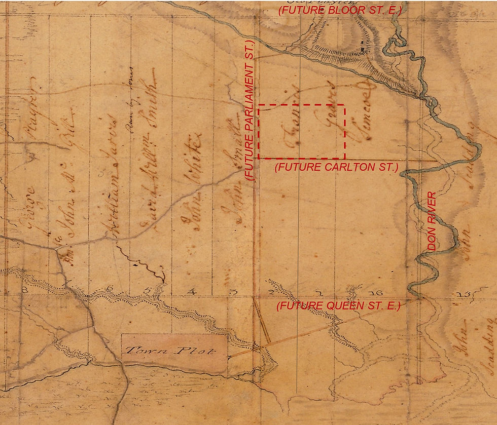
Map 1: 1793 Crown grants map showing part of the 1st Concession of York Township (bounded by modern day Queen and Bloor Streets) divided into north-south township lots 15 & 16 and park lots 1 through 8.

Map 2: Plan 26 (registered in 1844) subdivided the outlined area in Map 1.

Map 3: Plan D49 (registered in 1868) subdivided the largest of the outlined areas in Map 2.
The end result of these three stages of subdivision is captured in the following excerpt from the 1884 Toronto atlas:

Here, the numbers and north-south borders of the original Concession lots are indicated along Winchester Street while the subsequent Registered Plan numbers are noted in ovals and their corresponding lot numbers are identified by the numerals within the boundaries of those lots.
The challenge of depicting multiple layers of registered plans in a two-dimensional medium becomes apparent as lot boundaries and numbers from older plans become obscured by the details of more recent ones. This problem is even more evident in high-density neighbourhoods like the downtown block seen following where it is very difficult to determine which lot numbers pertain to which registered plans:

The benefits of Goad's suggestion to compare previous editions to new ones becomes clear when comparing the Cabbagetown area from the 1884 atlas to the same area in the subsequent 1890 edition below. Within this six-year gap it can be seen that parts of plan D49 have in turn been subdivided by a new plan numbered 577 to create even smaller building lots.
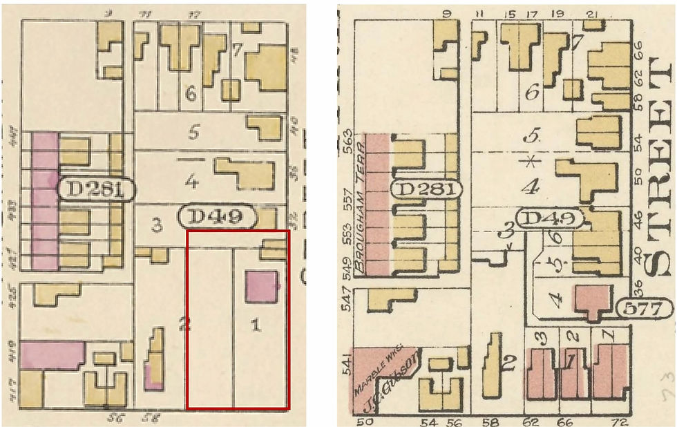
The same block in the 1884 and 1890 editions of the atlas.
Keen-eyed readers may have also observed that the excerpts above include subdivided lots that are not incorporated into a Registered Plan. This is because there was no legal requirement to submit an official plan when subdividing land which meant the owner of lots 6 and 7 in Plan D49 was free to carve up his combined property into five smaller plots and sell them to separate buyers.
Ontario Land Registry Online
Fortunately for today’s researchers, peeling back the layers of subdivisions depicted in the atlases can be done more effectively with the aid of provincial land registry databases. Ontario’s digital land registry service is called OnLand and it has three primary tools for researching historical property ownership: an interactive property map, digitized historical Registered Plans, and digitized historical abstracts of property transactions.
OnLand Property Map
OnLand offers interactive maps of all properties that fall within each Land Registry Office (LRO) jurisdiction. The Toronto LRO map is essentially the digital equivalent of Goad’s Toronto atlas minus the buildings, an omission that makes it much easier to identify plan and lot numbers that apply to modern addresses as seen in the following comparison.

The same block in a 1910 atlas and the OnLand property map. Both include former street names.
This digital cadastral map also provides a more clear distinction between Registered Plan lots and their subsequent subdivisions: lots from the most recent Registered Plans on file are outlined in green and the current subdivision of those lots are outlined in grey[11].
Digitized Registered Plans
Another useful OnLand tool is digitized versions of the actual registered plans[12]. As seen in the scans of Plan 26 and Plan D49 above, they provide notable details about the corresponding property, some of which are not found in the atlas or even the online map. This includes:
the date the plan was surveyed and the date it was registered
lot dimensions
in the case of older plans, numbers of lots that were later subdivided into newer plans (which are no longer noted in atlases or the OnLand map)
in the case of newer plans, the number of the preceding plan (and lots) they replaced
the identity of the plan that established the neighbourhood’s streets
Abstracts
After determining the sequence of plans (and lots) that apply to a property’s past, researchers can utilize land registry abstracts to determine the property’s complete ownership history. Abstracts are ledgers that summarize legal transactions pertaining to a particular piece of property such as deeds of sale, mortgages and foreclosures.

1890 Toronto atlas.
Returning to our Cabbagetown example, it's possible to track the history of 72 Winchester Street (highlighted by the red marker) by viewing OnLand’s digitized abstracts for the four registered plans associated with this property in chronological order:
Abstracts for Park Lots 1 & 2 and Township Lot 16 provide ownership information from the lots' original grant date circa 1793 to the creation of Plan 26 spanning a part of those lots in 1844.
The abstracts for Lot 7 & 8 in Plan 26 indicate land ownership from that plan’s 1844 creation date to the subdivision of those lots by Plan D49 in 1868.
The abstracts for Lot 1 in Plan D49 span from the time of that plan’s registration in 1868 to the subdivision of the lot by Plan 577 in 1885.
Finally, the abstracts for Part Lot 1 in Plan 577 summarize ownership from 1885 to approximately 2000 when the LRO ceased using physical ledgers[13].

Example of Ontario Land Registry abstract.
Of the three OnLand tools described here, the digital map is relatively simple to use but retrieving historical registered plans and abstracts can be a complex undertaking that falls outside the scope of this Guide. Researchers will need to find instructions elsewhere like this excellent webinar from the Ontario Genealogical Society.
Notes
HISTORY
[1] These Ontario atlases would published under the US company name rather than the deceptive “Provincial” imprint used in Halifax and Quebec.
[2] Charles Goad’s records contain no other indication of the intended audience for these atlases beyond this quotation. Archivists (who don't mistake these atlases for fire insurance maps) generally assume he was targeting the real estate market, likely because of the maps’ emphasis on cadastral plans.
[3] Volumes 1 and 2 were published in 1912 and the New Westminster portion of volume 3 was issued in 1913.
[4] This company name is listed in the 1925 Toronto city directory only. In the following year’s directory it returns to being listed as Chas E. Goad Co. and no longer has an office, only a representative working out of a different location.
[5] The purchase would have taken place around 1925 as the business only operated under this name from 1924-1926. A few archives have mistakenly credited them as the publisher of the 1923-24 Toronto revisions because some copies have a Wilson & Bunnell sticker affixed overtop of the original Goad’s Atlas and Plan imprint. This sticker also appears over original imprints on some copies of Vancouver atlases.
FORMAT
[6] The latter format was accomplished by adding a strip of paper along the crease of the unprinted side which was inserted into the book’s spine.
CONTENT
[7] In this particular excerpt, Plan 147 has identically numbered lots on each side of the block. Land Registry abstracts distinguished them by identifying the name of the street they bordered: either “west side of Centre Avenue” or “east side of University Avenue” (the street on the left). This practice was not uncommon for 1880s subdivisions in Toronto's downtown core but without this context atlas readers can easily mistakenly conclude that Goad has indicated incorrect lot numbers.
CADASTRAL MAPS
[8] British Columbia's land registry also manages Reference Plans which are used to carve out smaller interests or designated portions of an existing parcel without necessarily creating a new, independent lot.
[9] Toronto's park lots are unique to the city. Shortly after surveying the standard 200-acre township lots in York Township, the Upper Canada government decided that the ones closest to the town of York would be in high demand and so divided them into two 100-acre parcels they called park lots.
[10] Toronto atlas title pages state that Goad also included some private subdivision plans which had not yet been registered with the city, at the request of the owners. This is important to note when there’s a discrepancy between the year a registered plan appears in an atlas and the year it was filed with the land registry office.
ONTARIO LAND REGISTRY SIDEBAR
[11] The existence of these sublots is one of the reasons that Land Registry Offices define properties by plan and lot numbers, not by street addresses. Goad’s atlas might refer to the buildings on lot 15 as numbers 96 and 100 Augusta Avenue but the LRO identifies them as “part lot 5, plan D55” and differentiates them with property measurements relative to nearby landmarks.
[12] Note that plans for original Township Lots are not held by land registry offices. Maps containing this information (usually called Patent Plans) can be found at the Archives of Ontario and various local history websites. These boundaries are also noted in LRO digital maps.
[13] LRO entries subsequent to 2000 have been recorded electronically and are available by purchasing a parcel register for the desired address.
Illustration Credits
PAGE HEADER
Goad Toronto atlas (no volume), 1884, plate 5: Toronto Archives
HISTORY
Provincial Surveying & Publishing atlas of Halifax, 1878: Library and Archives Canada
atlas detail comparison:
Provincial Surveying & Publishing atlas of Montreal, 1881, plate F: Bibliothèque et Archives nationales du Québec
Goad Montreal atlas (no volume), 1881, plate 4: Library and Archives Canada
Goad Plan & Atlas Company imprint: Toronto Atlas volume 1, 1923; Toronto Archives F2 S2421 fi29 item1
FORMAT
cover of Vancouver atlas: eBay
key plan of Montreal atlas volume 1, revised 1890, plate 1: Library and Archives Canada
cover of Toronto atlas (no volume), 1884: Toronto Public Library via "Goad's Atlas of the City of Toronto"
Toronto atlas interior: Abe Books
CONTENT
front matter from Toronto atlas volume 1, 1910: Toronto Public Library via "Goad's Atlas of the City of Toronto"
legend examples
Montreal atlas (no volume), 1881, plate 5: Bibliothèque et Archives nationales du Québec
Toronto atlas volume 1, 1910: Toronto Public Library via "Goad's Atlas of the City of Toronto"
Vancouver atlas volume 1, 1912: Vancouver Archives
atlas to plan comparison
Toronto atlas (no volume), 1890: Toronto Public Library via "Goad's Atlas of the City of Toronto"
Toronto plan volume 1, 1889: Toronto Public Library Digital Archive Ontario
Montreal atlas (no volume), 1881: Bibliothèque et Archives nationales du Québec
REVISIONS
Montreal atlas volume 1, 1890: Library and Archives Canada
ACCURACY
Toronto atlas volume 1, 1910 revised to 1912, plate 27: Library and Archives Canada
Toronto plan volume 3, 1911 revised to 1914, sheet 207: Peter Marshall
CADASTRAL MAPS
Header: instrument MBP287YK, Ontario Land Registry Office #80
Map 1: Peter Marshall
Map 2: instrument MBP26A, Ontario Land Registry Office #80
Map 3: instrument MBP49D, Ontario Land Registry Office #80
Cabbagetown excerpt from Toronto Atlas 1884 Plate 27: Toronto Archives
ONTARIO LAND REGISTRY SIDEBAR
Goad Toronto atlas volume 1, 1910, plate 23: Toronto Public Library
Goad Toronto atlas (no volume), 1890, plate 27: Toronto Archives
The Hogtown Guide to Goad's Maps
ABOUT | HISTORY | FIRE INSURANCE PLANS | CITY ATLASES | COLLECTIONS | TORONTO MAPS


I enjoyed reading this article because it explained that packaging is an important part of how customers experience a product from the very beginning. Before the item is even opened, the condition and appearance of the box can shape expectations and reflect the care taken by the business. While researching ideas for improving our packaging approach, I explored custom boxes London to compare different styles suitable for retail products, online orders, and promotional campaigns. I found the section about selecting packaging that matches the product particularly useful because the right size and structure help reduce movement during shipping while creating a cleaner presentation. Those practical details often save time and reduce unnecessary issues during delivery. During the same research, I also…
I was impressed by how clearly this article explains the importance of hiring experienced Best Plumbers in Greenwood IN. Reliable professionals can identify hidden issues before they become expensive repairs. This guide offers practical advice that every homeowner should keep in mind when choosing plumbing services.